IMAGES TAKEN NEAR TO
Boleran Road, COLERAINE, BT51 4HT
Introduction
This page details the photographs taken nearby to Boleran Road, BT51 4HT by members of the Geograph project.
The Geograph project started in 2005 with the aim of publishing, organising and preserving representative images for every square kilometre of Great Britain, Ireland and the Isle of Man.

There are currently over 7.5m images from over14,400 individuals and you can help contribute to the project by visiting https://www.geograph.org.uk
Image Map
Images are licensed for reuse under creativecommons.org/licenses/by-sa/2.0
Notes
- Clicking on the map will re-center to the selected point.
- The higher the marker number, the further away the image location is from the centre of the postcode.
Image Listing (4 Images Found)
Images are licensed for reuse under creativecommons.org/licenses/by-sa/2.0
Image
Details
Distance
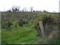
2
Near Rindsend
Looking west from the Shanlongford Road
Image: © Kenneth Allen
Taken: 16 Apr 2008
0.10 miles
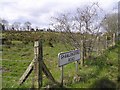
3

Stone Building at Ringsend
Located on the Boleran Road
Image: © Kenneth Allen
Taken: 16 Apr 2008
0.12 miles
4
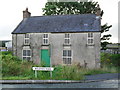
Derelict House, Ringsend
On the Boleran Road - full credit to whoever has spruced up the windows with the mock sash effect!
Image: © Dean Molyneaux
Taken: 23 Aug 2009
0.24 miles