IMAGES TAKEN NEAR TO
Mullaghinch Road, COLERAINE, BT51 4DY
Introduction
This page details the photographs taken nearby to Mullaghinch Road, BT51 4DY by members of the Geograph project.
The Geograph project started in 2005 with the aim of publishing, organising and preserving representative images for every square kilometre of Great Britain, Ireland and the Isle of Man.

There are currently over 7.5m images from over14,400 individuals and you can help contribute to the project by visiting https://www.geograph.org.uk
Image Map
Images are licensed for reuse under creativecommons.org/licenses/by-sa/2.0
Notes
- Clicking on the map will re-center to the selected point.
- The higher the marker number, the further away the image location is from the centre of the postcode.
Image Listing (4 Images Found)
Images are licensed for reuse under creativecommons.org/licenses/by-sa/2.0
Image
Details
Distance
1
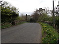
Moneybrannon Road
The parapets of the bridge under which the old Derry Central railway ran between 1880 and 1959. Almost nothing can be seen of the trackbed from the bridge owing to trees and bushes but the station house still exists as a private dwelling somewhere in the vicinity - if I can find it! This station once served Aghadowey.
Image: © Robert Ashby
Taken: 23 Apr 2017
0.03 miles
3
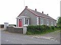
Glenkeen Orange Hall
Located on the Glenkeen Road. The inscription on the plaque reads, "Glenkeen Orange Hall 1929. This stone was laid by Mrs J.M. Mark 22nd June, 1929"
Image: © Kenneth Allen
Taken: 9 Jun 2008
0.17 miles
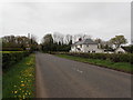
4
Moneybrannon Road
Heading south-east towards Cullycapple
Image: © Kenneth Allen
Taken: 3 Jun 2008
0.17 miles