IMAGES TAKEN NEAR TO
Ardreagh Road, COLERAINE, BT51 4DW
Introduction
This page details the photographs taken nearby to Ardreagh Road, BT51 4DW by members of the Geograph project.
The Geograph project started in 2005 with the aim of publishing, organising and preserving representative images for every square kilometre of Great Britain, Ireland and the Isle of Man.

There are currently over 7.5m images from over14,400 individuals and you can help contribute to the project by visiting https://www.geograph.org.uk
Image Map
Images are licensed for reuse under creativecommons.org/licenses/by-sa/2.0
Notes
- Clicking on the map will re-center to the selected point.
- The higher the marker number, the further away the image location is from the centre of the postcode.
Image Listing (4 Images Found)
Images are licensed for reuse under creativecommons.org/licenses/by-sa/2.0
Image
Details
Distance
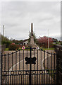
1
Aghadowey Presbyterian Church
It is located at Ardreagh Road
Image: © Kenneth Allen
Taken: 3 Jun 2008
0.00 miles
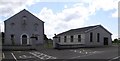
2
Aghadowey Public Elementary School
It was constructed in 1910
Image: © Kenneth Allen
Taken: 3 Jun 2008
0.00 miles
3
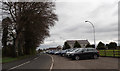
Ardreagh Road
Sunday morning line-up outside Aghadowey Presbyterian Church.
Image: © Robert Ashby
Taken: 23 Apr 2017
0.05 miles