IMAGES TAKEN NEAR TO
Castlerock Road, COLERAINE, BT51 3TB
Introduction
This page details the photographs taken nearby to Castlerock Road, BT51 3TB by members of the Geograph project.
The Geograph project started in 2005 with the aim of publishing, organising and preserving representative images for every square kilometre of Great Britain, Ireland and the Isle of Man.

There are currently over 7.5m images from over14,400 individuals and you can help contribute to the project by visiting https://www.geograph.org.uk
Image Map
Images are licensed for reuse under creativecommons.org/licenses/by-sa/2.0
Notes
- Clicking on the map will re-center to the selected point.
- The higher the marker number, the further away the image location is from the centre of the postcode.
Image Listing (93 Images Found)
Images are licensed for reuse under creativecommons.org/licenses/by-sa/2.0
Image
Details
Distance
1
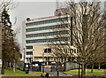
County Hall, Coleraine (2)
See Image (October 2006). County Hall seen from the Castlerock Road. It was built for the old Londonderry County Council. Following the reorganisation of local government (nearly 40 years ago) it now houses various central Government offices.
Image: © Albert Bridge
Taken: 24 Mar 2012
0.05 miles
2
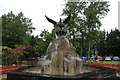
Phoenix fountain, rose garden, Coleraine
In contrast to its nearby cousin, the Phoenix fountain, in the rose garden section of Anderson Park, off the Millburn Road was erected in 2002. There is much symbolism surrounding it but essentially it is supposed to represent peace in NI. The columns are shaped in the manner of the Giant’s Causeway.
Image: © Albert Bridge
Taken: 15 Aug 2006
0.06 miles
3
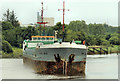
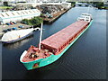
The "Peak Oslo", Coleraine (1)
The coaster “Peak Oslo” arriving at Coleraine to load a cargo of scrap. See also Image
Image: © Albert Bridge
Taken: 3 Aug 2012
0.13 miles
4
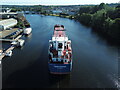
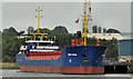
Fehn Calypso
Fehn Calypso enters Coleraine Harbour.
Image: © KS
Taken: 10 Aug 2022
0.13 miles
5
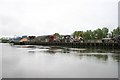
Coleraine Harbour
The quay, fronting on the River Bann, is mainly used for exports of scrap
Image: © Bob Jones
Taken: 27 May 2005
0.14 miles
6
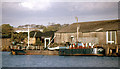
The "Kingsdale H", Coleraine
Belfast had two “sludge” boats to carry waste, from the sewage works, to the dumping grounds – the “Divis II” Image and the “St Stephen” Image Coleraine required one which operated (1981-89) part-time. The “Kingsdale H” had been built as a bunkering tanker (for an explanation see Image). This part of Coleraine harbour was subsequently rebuilt. Her port of registry was Hull.
Image: © Albert Bridge
Taken: 11 Oct 1986
0.14 miles
7
The "Glenfyne" at Coleraine
The coaster “Glenfyne” at Coleraine. She had loaded building materials and was awaiting the tide before departure.
Image: © Albert Bridge
Taken: 24 Mar 1993
0.14 miles
8
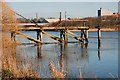
Disused jetty, Coleraine
Once upon a time Chemstrand (later Monsanto (background in Image)) had a factory in Coleraine making man-made fibres. This jetty, on the western side of the Bann, was used to import raw materials. The jetty remains but the factory is long gone.
A visitor to the site has suggested that the jetty was too far from the Monsanto factory and was more likely to have been used by Pickerings.
My caption was based on published material and information supplied by the River Bann pilot. You may make your own decision.
Image: © Albert Bridge
Taken: 8 Feb 2008
0.14 miles
9
Athos departs Coleraine
Athos departs Coleraine with a cargo of scrap metal.
Image: © KS
Taken: 26 Jul 2022
0.14 miles
10
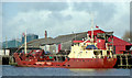
The "Eems Stream" at Coleraine
The coaster “Eems Stream” (the fourteenth ship in 2012) arrived earlier in the afternoon to load a cargo of scrap. She was due to shift following departure of the “Kliftrans” but was unable to do so as noted in Image
Image: © Albert Bridge
Taken: 14 Jun 2012
0.14 miles