IMAGES TAKEN NEAR TO
Masteragwee Crescent, COLERAINE, BT51 3NU
Introduction
This page details the photographs taken nearby to Masteragwee Crescent, BT51 3NU by members of the Geograph project.
The Geograph project started in 2005 with the aim of publishing, organising and preserving representative images for every square kilometre of Great Britain, Ireland and the Isle of Man.

There are currently over 7.5m images from over14,400 individuals and you can help contribute to the project by visiting https://www.geograph.org.uk
Image Map
Images are licensed for reuse under creativecommons.org/licenses/by-sa/2.0
Notes
- Clicking on the map will re-center to the selected point.
- The higher the marker number, the further away the image location is from the centre of the postcode.
Image Listing (6 Images Found)
Images are licensed for reuse under creativecommons.org/licenses/by-sa/2.0
Image
Details
Distance
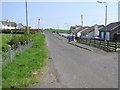
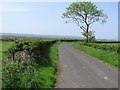
1
Quilly Road
On Quilly Road we are just passing the exit / entrance to a short loop of road on the left of the A2.
Image: © Malcolm Neal
Taken: 27 Jul 2022
0.07 miles
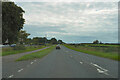
4
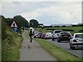
Quilly Road
The busy A2, west of Coleraine.
Image: © Richard Webb
Taken: 4 Aug 2013
0.15 miles