IMAGES TAKEN NEAR TO
Lislea Court, COLERAINE, BT51 3HN
Introduction
This page details the photographs taken nearby to Lislea Court, BT51 3HN by members of the Geograph project.
The Geograph project started in 2005 with the aim of publishing, organising and preserving representative images for every square kilometre of Great Britain, Ireland and the Isle of Man.

There are currently over 7.5m images from over14,400 individuals and you can help contribute to the project by visiting https://www.geograph.org.uk
Image Map
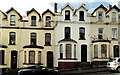
Images are licensed for reuse under creativecommons.org/licenses/by-sa/2.0
Notes
- Clicking on the map will re-center to the selected point.
- The higher the marker number, the further away the image location is from the centre of the postcode.
Image Listing (130 Images Found)
Images are licensed for reuse under creativecommons.org/licenses/by-sa/2.0
Image
Details
Distance
1
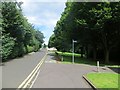
Cycle path, Coleraine
A typical Sustrans convolution through a green space in Coleraine.
Image: © Richard Webb
Taken: 4 Aug 2013
0.02 miles
2
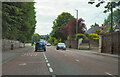
Castlerock Road
Rather nice houses on both sides of Castlerock Road. Most have serious stone wall separating them from the pavement and road.
Image: © Malcolm Neal
Taken: 27 Jul 2022
0.04 miles
3
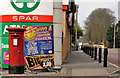
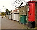
Pillar box, Coleraine
EIIR pillar box (BT51 3) at the Spar/petrol station/post office on the Castlerock Road. The post office was previously at no 14 The Waterside (slightly further down the hill).
Image: © Albert Bridge
Taken: 24 Mar 2012
0.11 miles
4
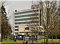
County Hall, Coleraine (2)
See Image (October 2006). County Hall seen from the Castlerock Road. It was built for the old Londonderry County Council. Following the reorganisation of local government (nearly 40 years ago) it now houses various central Government offices.
Image: © Albert Bridge
Taken: 24 Mar 2012
0.13 miles
5
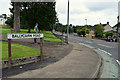
Pillar box, Coleraine
EIIR pillar box (BT51 65) on the Ballycairn Road, beside the roundabout on the Castlerock Road.
Image: © Albert Bridge
Taken: 24 Mar 2012
0.13 miles
6
Ballycairn Road, Waterside, Coleraine
Heading north from Castlerock Road
Image: © Kenneth Allen
Taken: 19 Aug 2020
0.14 miles
7
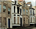
Nos 30-36 Captain Street Lower, Coleraine
Nos 30 (left) – 36. No 32 has suffered fire damage.
Image: © Albert Bridge
Taken: 3 Aug 2012
0.15 miles
8
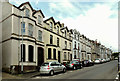
Nos 14-36 Captain Street Lower, Coleraine
The entire row with no 14 on the left.
Image: © Albert Bridge
Taken: 3 Aug 2012
0.15 miles
9
Nos 16-22 Captain Street Lower, Coleraine
Nos 16 (left) – 22.
Image: © Albert Bridge
Taken: 3 Aug 2012
0.16 miles
10
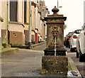
Old Glenfield fountain, Coleraine (1)
A Glenfield & Kennedy (Kilmarnock) drinking fountain, still with a water supply, at Captain Street Lower. Image shows the maker’s name.
Image: © Albert Bridge
Taken: 29 Feb 2012
0.16 miles