IMAGES TAKEN NEAR TO
Waterside, COLERAINE, BT51 3DP
Introduction
This page details the photographs taken nearby to Waterside, BT51 3DP by members of the Geograph project.
The Geograph project started in 2005 with the aim of publishing, organising and preserving representative images for every square kilometre of Great Britain, Ireland and the Isle of Man.

There are currently over 7.5m images from over14,400 individuals and you can help contribute to the project by visiting https://www.geograph.org.uk
Image Map
Images are licensed for reuse under creativecommons.org/licenses/by-sa/2.0
Notes
- Clicking on the map will re-center to the selected point.
- The higher the marker number, the further away the image location is from the centre of the postcode.
Image Listing (249 Images Found)
Images are licensed for reuse under creativecommons.org/licenses/by-sa/2.0
Image
Details
Distance
1
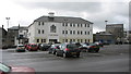
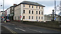
River House, Coleraine
Situated at the rear of Waterside this modern building is used by several organisations. The site had formerly been used as a shirt factory and for many other small businesses.
Image: © Willie Duffin
Taken: 9 Apr 2012
0.01 miles
2
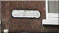
Name plate, Coleraine
Old style name plate.
Image: © Willie Duffin
Taken: 9 Apr 2012
0.01 miles
3
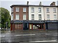
Pizza Pomedoro, Coleraine
Pictured in Waterside Street
Image: © Kenneth Allen
Taken: 25 Aug 2024
0.01 miles
4
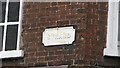
Name plate, Coleraine
Another old style name plate on the Strand Road.
Image: © Willie Duffin
Taken: 9 Apr 2012
0.02 miles
5
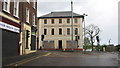
Cloth Workers Building, Coleraine
Still unoccupied and slowly deteriorating. The Clothworkers was one of the guilds of wealthy London merchants charged with improving the town of Coleraine during the early 17th century. Following the construction of the new bridge across the River Bann they commissioned the same architect who had built the bridge,John Lynn to design and construct this building in 1844. It was built at a cost of £2000 and became known as the Clothworkers, or Davock's Hotel.
Image: © Willie Duffin
Taken: 9 Apr 2012
0.02 miles
6
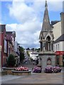
Bridge Street and beyond
Seen from The Diamond, near the Orr memorial fountain, is this view of Bridge Street and over Bann Bridge.
Image: © Michael Dibb
Taken: 30 Jul 2017
0.02 miles
7
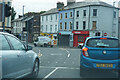
Waiting at traffic lights
One of the few times we stopped on our outward journey, as this busy junction was controlled by traffic lights.
Image: © Malcolm Neal
Taken: 27 Jul 2022
0.02 miles
8
Cloth Workers Building, Coleraine (2)
Taken from the river bridge.
Image: © Willie Duffin
Taken: 9 Apr 2012
0.02 miles
9
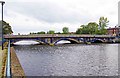
Town Bridge, Coleraine
The bridge was completed in 1844 and carries the A2 road across the River Bann.
Image
Image: © P L Chadwick
Taken: 23 Sep 2011
0.02 miles
10
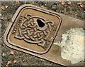
"Innovative" access cover, Coleraine
One of several small access cover (all with a blob of cement) in the Waterside, near the pedestrian entrance to the car park, bearing a Celtic design and the inscription “Innovative Products”. Made in Drogheda http://www.iplgroup.com/assets/downloads/certificates/ORBITAL_DuctileIron_01.pdf?PHPSESSID=e0abe7c11fc7ce9870d421732d6398b4 .
Image: © Albert Bridge
Taken: 3 Aug 2012
0.02 miles