IMAGES TAKEN NEAR TO
Molesworth Lane, LIMAVADY, BT49 9NX
Introduction
This page details the photographs taken nearby to Molesworth Lane, BT49 9NX by members of the Geograph project.
The Geograph project started in 2005 with the aim of publishing, organising and preserving representative images for every square kilometre of Great Britain, Ireland and the Isle of Man.

There are currently over 7.5m images from over14,400 individuals and you can help contribute to the project by visiting https://www.geograph.org.uk
Image Map
Images are licensed for reuse under creativecommons.org/licenses/by-sa/2.0
Notes
- Clicking on the map will re-center to the selected point.
- The higher the marker number, the further away the image location is from the centre of the postcode.
Image Listing (8 Images Found)
Images are licensed for reuse under creativecommons.org/licenses/by-sa/2.0
Image
Details
Distance
1
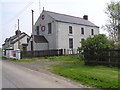
Myroe Orange Hall
Built in 1903 , it is located near Carrowclare
Image: © Kenneth Allen
Taken: 6 May 2008
0.10 miles
2
Carrowclare Road, Carrowclare
Heading NNE
On the right is Image]
Image: © Kenneth Allen
Taken: 18 Jul 2017
0.15 miles
4
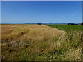
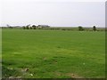
Barley field, Carrowclare
Looking north-west from Carrowclare Road
Image: © Kenneth Allen
Taken: 18 Jul 2017
0.17 miles
5
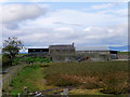
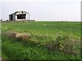
Farm Buildings near the Derry to Belfast Railway Line
Image: © David Dixon
Taken: 28 Sep 2017
0.22 miles
6
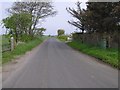
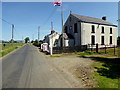
Carrowclare Road
Heading towards Carrowclare from Ballymacran
Image: © Kenneth Allen
Taken: 6 May 2008
0.23 miles
7
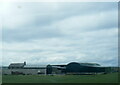
Farm seen from Derry train at Carrowclare
Image: © Colin Pyle
Taken: 30 Jul 2022
0.23 miles