IMAGES TAKEN NEAR TO
Drumacony Heights, LIMAVADY, BT49 9NR
Introduction
This page details the photographs taken nearby to Drumacony Heights, BT49 9NR by members of the Geograph project.
The Geograph project started in 2005 with the aim of publishing, organising and preserving representative images for every square kilometre of Great Britain, Ireland and the Isle of Man.

There are currently over 7.5m images from over14,400 individuals and you can help contribute to the project by visiting https://www.geograph.org.uk
Image Map
Images are licensed for reuse under creativecommons.org/licenses/by-sa/2.0
Notes
- Clicking on the map will re-center to the selected point.
- The higher the marker number, the further away the image location is from the centre of the postcode.
Image Listing (5 Images Found)
Images are licensed for reuse under creativecommons.org/licenses/by-sa/2.0
Image
Details
Distance
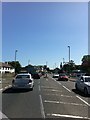
1
Loughermore Road, Ballykelly
Heading south from Clooney Road
Image: © Kenneth Allen
Taken: 4 Nov 2021
0.21 miles
2
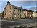
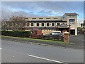
Bridge House, Ballykelly
Pictured along Clooney Road
Image: © Kenneth Allen
Taken: 4 Nov 2021
0.23 miles
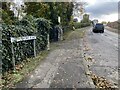
3
Station Road, Ballykelly
Heading north-west from Clooney Road
Image: © Kenneth Allen
Taken: 4 Nov 2021
0.25 miles
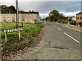
4
The Well Inn Bar & Bistro, Ballykelly
Pictured along Plantation Road
Image: © Kenneth Allen
Taken: 4 Nov 2021
0.25 miles