IMAGES TAKEN NEAR TO
Seacoast Road, LIMAVADY, BT49 0LL
Introduction
This page details the photographs taken nearby to Seacoast Road, BT49 0LL by members of the Geograph project.
The Geograph project started in 2005 with the aim of publishing, organising and preserving representative images for every square kilometre of Great Britain, Ireland and the Isle of Man.

There are currently over 7.5m images from over14,400 individuals and you can help contribute to the project by visiting https://www.geograph.org.uk
Image Map
Images are licensed for reuse under creativecommons.org/licenses/by-sa/2.0
Notes
- Clicking on the map will re-center to the selected point.
- The higher the marker number, the further away the image location is from the centre of the postcode.
Image Listing (7 Images Found)
Images are licensed for reuse under creativecommons.org/licenses/by-sa/2.0
Image
Details
Distance
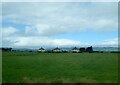
1
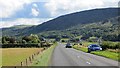
Seacoast Road
The A2 on the edge of the Magilligan flatlands.
Image: © Richard Webb
Taken: 4 Aug 2013
0.08 miles
4
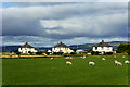
Houses on Seacroft Road from a passing train
Image: © Colin Pyle
Taken: 30 Jul 2022
0.21 miles
5
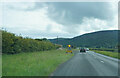
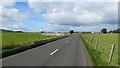
Speed warning on the A2
There didn't appear to be any speed restriction nor any road works but he temporary speed warning sign was lighting for each vehicle as it passed.
Image: © Malcolm Neal
Taken: 27 Jul 2022
0.21 miles
6
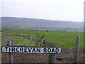
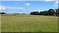
Aughit Townland
Looking east from the Tircrevan Road
Image: © Kenneth Allen
Taken: 6 May 2008
0.24 miles