IMAGES TAKEN NEAR TO
Windyhill Road, LIMAVADY, BT49 0JW
Introduction
This page details the photographs taken nearby to Windyhill Road, BT49 0JW by members of the Geograph project.
The Geograph project started in 2005 with the aim of publishing, organising and preserving representative images for every square kilometre of Great Britain, Ireland and the Isle of Man.

There are currently over 7.5m images from over14,400 individuals and you can help contribute to the project by visiting https://www.geograph.org.uk
Image Map
Images are licensed for reuse under creativecommons.org/licenses/by-sa/2.0
Notes
- Clicking on the map will re-center to the selected point.
- The higher the marker number, the further away the image location is from the centre of the postcode.
Image Listing (6 Images Found)
Images are licensed for reuse under creativecommons.org/licenses/by-sa/2.0
Image
Details
Distance
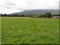
1
Aghanloo Road
Heading NNW from Windyhill Road
Image: © Kenneth Allen
Taken: 24 May 2015
0.17 miles
2
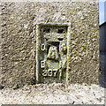
Flush Bracket, Artikelly
Flush bracket bench mark on the north-eastern tip of Aghanloo Orange Hall, Artikelly Image
The number on the bracket is OSBM 3371.
The mark has been levelled to 23.79 metres above MSL.
Image: © Rossographer
Taken: 8 Jun 2018
0.17 miles
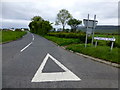
3
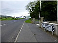
Road junction, Artikelly
Junction of the Aghanloo Road (ahead) and Windyhill Road (right) at Artikelly.
Image: © Rossographer
Taken: 8 Jun 2018
0.18 miles
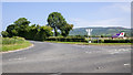
4
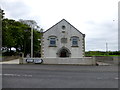
Aghanloo Orange Hall
It is located at the junction of Windyhill Road and Aghanloo Road
Image: © Kenneth Allen
Taken: 24 May 2015
0.19 miles
5
Windyhill Road
Heading ENE from the junction with Aghanloo Road
Image: © Kenneth Allen
Taken: 24 May 2015
0.21 miles