IMAGES TAKEN NEAR TO
Seacoast Road, LIMAVADY, BT49 0JB
Introduction
This page details the photographs taken nearby to Seacoast Road, BT49 0JB by members of the Geograph project.
The Geograph project started in 2005 with the aim of publishing, organising and preserving representative images for every square kilometre of Great Britain, Ireland and the Isle of Man.

There are currently over 7.5m images from over14,400 individuals and you can help contribute to the project by visiting https://www.geograph.org.uk
Image Map
Images are licensed for reuse under creativecommons.org/licenses/by-sa/2.0
Notes
- Clicking on the map will re-center to the selected point.
- The higher the marker number, the further away the image location is from the centre of the postcode.
Image Listing (8 Images Found)
Images are licensed for reuse under creativecommons.org/licenses/by-sa/2.0
Image
Details
Distance
1
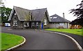
Bellarena Primary School, 260 Sea Coast Road, near Limavady, Co. Derry
Small primary school, located on the A2, serving the surrounding rural area.
Image: © P L Chadwick
Taken: 16 Jun 2017
0.01 miles
2

Bus stop and shelter, Sea Coast Road, near Limavady, Co. Derry
Located outside Bellarena Primary School on the A2 (Sea Coast Road). It can also be seen in this view:- Image
Image: © P L Chadwick
Taken: 16 Jun 2017
0.02 miles
3
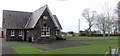
Bellarena Primary School
It is located at Glebe Townland.
Image: © Kenneth Allen
Taken: 16 Feb 2007
0.03 miles
4
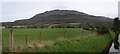
Glebe, Derry/Londonderry
Binevenagh is in the distance
Image: © Kenneth Allen
Taken: 16 Feb 2007
0.03 miles
5
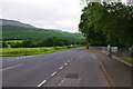
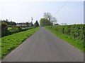
A2 (Sea Coast Road), near Limavady, Co. Derry
The road is passing Bellarena Primary School, which is on the right. The road coming in on the left is Duncrun Road.
Image
Image
Image: © P L Chadwick
Taken: 16 Jun 2017
0.03 miles
6
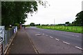
A2 (Sea Coast Road) passing Bellarena Primary School, near Limavady, Co. Derry
The road is passing the school, which is on the left.
Image
Image: © P L Chadwick
Taken: 16 Jun 2017
0.03 miles
7

Duncrun Road, near Limavady, Co. Derry
A turning off the A2 (Sea Coast Road) opposite Bellarena Primary School. The sign on the left indicates that the road gives access to St. Aidan's Church & Holy Well.
Image: © P L Chadwick
Taken: 16 Jun 2017
0.06 miles