IMAGES TAKEN NEAR TO
Little Diamond, LONDONDERRY, BT48 9ED
Introduction
This page details the photographs taken nearby to Little Diamond, BT48 9ED by members of the Geograph project.
The Geograph project started in 2005 with the aim of publishing, organising and preserving representative images for every square kilometre of Great Britain, Ireland and the Isle of Man.

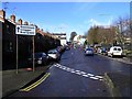
There are currently over 7.5m images from over14,400 individuals and you can help contribute to the project by visiting https://www.geograph.org.uk
Image Map
Images are licensed for reuse under creativecommons.org/licenses/by-sa/2.0
Notes
- Clicking on the map will re-center to the selected point.
- The higher the marker number, the further away the image location is from the centre of the postcode.
Image Listing (371 Images Found)
Images are licensed for reuse under creativecommons.org/licenses/by-sa/2.0
Image
Details
Distance
1
Derry - Bogside Area east of Fahan Street
Shown in the lower left corner of the photo is Fahan Street. To the right at the bottom of the photo is Operation Motorman Mural at the corner of Fahan St & Rossville St. In the upper right corner of the photo is St Eugene's Cathedral.
Image: © Joseph Mischyshyn
Taken: 24 Sep 2013
0.05 miles
2
Flats and Maisonettes in the Bogside
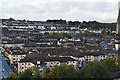
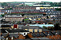
Anyone returning to Derry after an absence of thirty years would hardly recognise much of the city. This is more true of the Bogside than of most areas. This neighbourhood once notorious for its slums has been entirely transformed with new houses and apartments. A few landmarks, however, still survive, the most prominent in this photo is the Catholic cathedral of St Eugene.
Image: © Eric Jones
Taken: 6 Aug 2005
0.07 miles
3
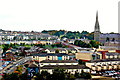
Marleborough Terrace, Derry / Londonderry
St Eugene's RC Cathedral is in the background
Image: © Kenneth Allen
Taken: 11 Oct 2006
0.07 miles
4
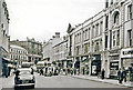
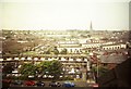
Londonderry 1960: south on Strand Road
View towards Waterloo Place. I wonder how much this has changed in 50+ years.
Image: © Ben Brooksbank
Taken: 10 Aug 1960
0.07 miles
5
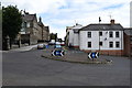
William Street Roundabout, Derry / Londonderry
Pictured at the junction of Creggan Street and William Street
Image: © Kenneth Allen
Taken: 17 Jul 2018
0.07 miles
6
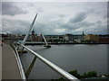
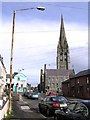
The Oak Grove
Taken from the eastern end of the Peace Bridge spanning the River Foyle, Derry / Londonderry, I am looking at the city centre, with Guildhall to the left, the City Hotel and the shopping centre running northwards along the Foyle Embankment and St Eugene's Cathedral on the horizon to the right of shot. The caption references the Irish origin of the name 'Derry' https://en.wikipedia.org/wiki/Derry .
Image: © Carroll Pierce
Taken: 10 Jul 2015
0.07 miles
7
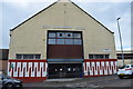
City Swimming Baths, Derry / Londonderry
Located along William Street
Image: © Kenneth Allen
Taken: 17 Jul 2018
0.08 miles
8
Creggan Street, Derry / Londonderry
Looking north-west
Image: © Kenneth Allen
Taken: 11 Feb 2009
0.08 miles
9
Derry - Abbey Street - Derry Credit Union
View is to the southwest from City Hotel Room #507 towards Derry Credit Union.
Image: © Joseph Mischyshyn
Taken: 24 Sep 2013
0.08 miles