IMAGES TAKEN NEAR TO
Barleyfields, LONDONDERRY, BT48 8TN
Introduction
This page details the photographs taken nearby to Barleyfields, BT48 8TN by members of the Geograph project.
The Geograph project started in 2005 with the aim of publishing, organising and preserving representative images for every square kilometre of Great Britain, Ireland and the Isle of Man.

There are currently over 7.5m images from over14,400 individuals and you can help contribute to the project by visiting https://www.geograph.org.uk
Image Map
Images are licensed for reuse under creativecommons.org/licenses/by-sa/2.0
Notes
- Clicking on the map will re-center to the selected point.
- The higher the marker number, the further away the image location is from the centre of the postcode.
Image Listing (5 Images Found)
Images are licensed for reuse under creativecommons.org/licenses/by-sa/2.0
Image
Details
Distance
1
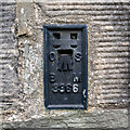
Flush Bracket, Culmore
Flush bracket bench mark on the southern wall of Culmore Parish Church Image The bracket is on a primary line from Derry to the fundamental bench mark close to the tidal station at Malin Head.
The number on the bracket is OSBM 3366.
The mark has been levelled to 38.23 metres above MSL.
Image: © Rossographer
Taken: 15 Aug 2023
0.09 miles
2
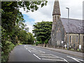
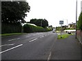
The Culmore Road at Culmore
The Culmore Road, with Culmore parish church on the right.
Image: © Rossographer
Taken: 15 Aug 2023
0.11 miles
4
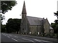
Culmore Church of Ireland
It is located to the north of Derry / Londonderry
Image: © Kenneth Allen
Taken: 5 Sep 2008
0.16 miles
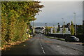
5
Road at Culmore
Heading SSW towards Derry / Londonderry
Image: © Kenneth Allen
Taken: 5 Sep 2008
0.16 miles