IMAGES TAKEN NEAR TO
Ballynagard Crescent, LONDONDERRY, BT48 8JR
Introduction
This page details the photographs taken nearby to Ballynagard Crescent, BT48 8JR by members of the Geograph project.
The Geograph project started in 2005 with the aim of publishing, organising and preserving representative images for every square kilometre of Great Britain, Ireland and the Isle of Man.

There are currently over 7.5m images from over14,400 individuals and you can help contribute to the project by visiting https://www.geograph.org.uk
Image Map
Images are licensed for reuse under creativecommons.org/licenses/by-sa/2.0
Notes
- Clicking on the map will re-center to the selected point.
- The higher the marker number, the further away the image location is from the centre of the postcode.
Image Listing (5 Images Found)
Images are licensed for reuse under creativecommons.org/licenses/by-sa/2.0
Image
Details
Distance
2
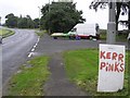
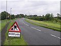
Culmore Road, Derry / Londonderry
Heading north-east out of the city; note Kerr Pinks are a popular variety of potato
Image: © Kenneth Allen
Taken: 5 Sep 2008
0.14 miles
3
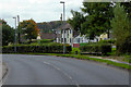
Culmore Road, Derry / Londonderry
Heading south-west towards the city
Image: © Kenneth Allen
Taken: 5 Sep 2008
0.20 miles
4
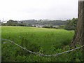
Through the wire
Looking east from the Culmore Road
Image: © Kenneth Allen
Taken: 5 Sep 2008
0.21 miles
5
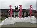
Sculptures, Thornhill College
An artwork by Eamon McAteer in the course of construction
More on the school at http://www.thornhillcollege.org.uk/
Image: © Kenneth Allen
Taken: 1 Aug 2012
0.23 miles