IMAGES TAKEN NEAR TO
Asylum Road, LONDONDERRY, BT48 7EA
Introduction
This page details the photographs taken nearby to Asylum Road, BT48 7EA by members of the Geograph project.
The Geograph project started in 2005 with the aim of publishing, organising and preserving representative images for every square kilometre of Great Britain, Ireland and the Isle of Man.

There are currently over 7.5m images from over14,400 individuals and you can help contribute to the project by visiting https://www.geograph.org.uk
Image Map
Images are licensed for reuse under creativecommons.org/licenses/by-sa/2.0
Notes
- Clicking on the map will re-center to the selected point.
- The higher the marker number, the further away the image location is from the centre of the postcode.
Image Listing (266 Images Found)
Images are licensed for reuse under creativecommons.org/licenses/by-sa/2.0
Image
Details
Distance
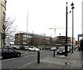
1
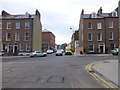
Queen Street, Derry / Londonderry
Looking north
Image: © Kenneth Allen
Taken: 21 Feb 2013
0.04 miles
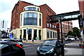
2
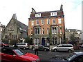
Clarendon House, Derry / Londonderry
It is located in Clarendon Street
Image: © Kenneth Allen
Taken: 23 Oct 2009
0.04 miles
3
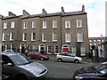
Terraced houses, Clarendon Street
Looking north
Image: © Kenneth Allen
Taken: 23 Oct 2009
0.05 miles
4
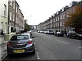
Clarendon Street, Derry / Londonderry
Looking east
Image: © Kenneth Allen
Taken: 23 Oct 2009
0.07 miles
5
Unison Building, Derry / Londonderry
It is listed as THE OLD CHURCH, 1 CLARENDON STREET
Image: © Kenneth Allen
Taken: 11 Feb 2009
0.07 miles
6
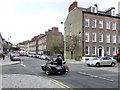
Motorcyclist, Derry / Londonderry
He was travelling along Clarendon Street - a brave soul today in the bitter cold.
Image: © Kenneth Allen
Taken: 21 Feb 2013
0.07 miles
7
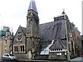
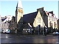
Former church
This former Reformed Presbyterian Church is at the junction of Clarendon Street and Queen Street. It was built in Gothic Revival style circa 1857. Now used as offices, the church is listed, grade B1, with much detail and history at: http://appsc.doeni.gov.uk/buildings/buildview.aspx?id=1012&js=false
Image: © Michael Dibb
Taken: 30 Jul 2017
0.08 miles
8
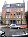
1-2 Clarendon Terrace
A fine pair of semi-detached houses in Clarendon Street a street where almost every building is listed. Built circa 1882, the houses are listed, grade B2, with details at: http://appsc.doeni.gov.uk/buildings/buildview.aspx?id=4420&js=false
Image: © Michael Dibb
Taken: 30 Jul 2017
0.08 miles
9
Strand Road Police Station, Derry / Londonderry
Still heavily fortified as most of the police stations are in Northern Ireland despite the apparent end of the troubles
Image: © Kenneth Allen
Taken: 23 Oct 2009
0.08 miles
10
North West Regional College, Derry / Londonderry
Located along Strand Road
Image: © Kenneth Allen
Taken: 17 Jul 2018
0.08 miles