IMAGES TAKEN NEAR TO
Fountain Street, LONDONDERRY, BT48 6QX
Introduction
This page details the photographs taken nearby to Fountain Street, BT48 6QX by members of the Geograph project.
The Geograph project started in 2005 with the aim of publishing, organising and preserving representative images for every square kilometre of Great Britain, Ireland and the Isle of Man.

There are currently over 7.5m images from over14,400 individuals and you can help contribute to the project by visiting https://www.geograph.org.uk
Image Map
Images are licensed for reuse under creativecommons.org/licenses/by-sa/2.0
Notes
- Clicking on the map will re-center to the selected point.
- The higher the marker number, the further away the image location is from the centre of the postcode.
Image Listing (1192 Images Found)
Images are licensed for reuse under creativecommons.org/licenses/by-sa/2.0
Image
Details
Distance
1
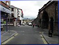
Artillery Street, Derry / Londonderry
Looking north-east, the famous city walls built in the 1600s are to the right
Image: © Kenneth Allen
Taken: 6 Aug 2010
0.00 miles
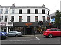
2
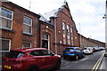
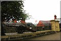
Housing Executive Offices, Derry / Londonderry
Pictured along Fountain Street
Image: © Kenneth Allen
Taken: 22 May 2019
0.01 miles
3
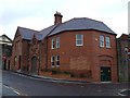
Fire Brigade Building, Derry / Londonderry
It is located near the Fountain Area
Image: © Kenneth Allen
Taken: 2 Mar 2009
0.01 miles
4
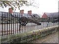
City Walls, Londonderry
Old artillery above Artillery Street. View over rooftops of The Fountain.
Image: © Richard Webb
Taken: 17 Oct 2012
0.02 miles
5
Clockwork Orange, Derry / Londonderry
It is located along Carlisle Road
Image: © Kenneth Allen
Taken: 1 Aug 2012
0.02 miles
6
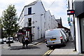
Fountain Street, Derry / Londonderry
Heading SSW from Foyleside Shopping Centre
Image: © Kenneth Allen
Taken: 22 May 2019
0.02 miles
7
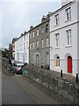
Georgian houses in Artillery Street, Derry
The middle house is derelict.
Image: © Eric Jones
Taken: 19 Aug 2009
0.02 miles
8
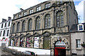
The Playhouse, Artillery Street, Londonderry / Derry
Grade B1 listed former national schoolhouse (No.7 St Mary's girls high school) was built 1887, the lower sections (Nos. 5-6), in view here were built 1911 and known as St. Joseph’s Primary School; however both schoolhouses continued to be collectively known as ‘the convent schools’. St Joseph's was designed by E.J. Toye. Still in use as a school in 1970 the school had vacated the site by the 1980s. Threatened with demolition in 1986 the buildings were eventually acquired by the DoE in the early 1990s. The Irish inscription above the door reads "The House of St Joseph for our Girls for the Convent of Mercy". The Playhouse was established in 1992. In 2004 The Playhouse won the N.Irish heat of the national television competition, BBC Restoration. The Playhouse re-launched on 27th November 2009 following a £4.6m refurbishment project undertaken by Andrzej Blonski Architects.
Image: © Jo and Steve Turner
Taken: 12 Sep 2006
0.02 miles
9
The Artillery Bastion
This lies between the Ferry Quay Gate and the New Gate.
Image: © Eric Jones
Taken: 19 Aug 2009
0.02 miles
10
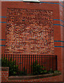
Mural, Fire Brigade Building, Derry / Londonderry
It is located here Image] I am not sure what the inscription means on this brick mural
Image: © Kenneth Allen
Taken: 2 Mar 2009
0.02 miles