IMAGES TAKEN NEAR TO
Anne Street, LONDONDERRY, BT48 6PB
Introduction
This page details the photographs taken nearby to Anne Street, BT48 6PB by members of the Geograph project.
The Geograph project started in 2005 with the aim of publishing, organising and preserving representative images for every square kilometre of Great Britain, Ireland and the Isle of Man.

There are currently over 7.5m images from over14,400 individuals and you can help contribute to the project by visiting https://www.geograph.org.uk
Image Map
Images are licensed for reuse under creativecommons.org/licenses/by-sa/2.0
Notes
- Clicking on the map will re-center to the selected point.
- The higher the marker number, the further away the image location is from the centre of the postcode.
Image Listing (6 Images Found)
Images are licensed for reuse under creativecommons.org/licenses/by-sa/2.0
Image
Details
Distance
2
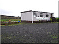
Foyle Racing Pigeon Society
The clubhouse is on the Letterkenny Road
Image: © Kenneth Allen
Taken: 18 Jan 2006
0.12 miles
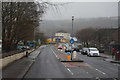
3
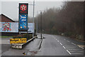
The A40, Letterkenny Road
On the outskirts of Londonderry / Derry.
Image: © Ian S
Taken: 26 Dec 2015
0.17 miles
5
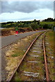
Old Derry/Donegal Railway Line
A popular path for city dwellers to walk and cycle.
Image: © louise price
Taken: 10 Jun 2009
0.19 miles
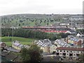
6
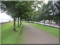
Park, Foyle Road
The A40 Foyle Road runs beside the river and the trackbed of the Londonderry and Enniskillen Railway which is now part of the Foyle Valley Railway Museum. The relaid track does not seem to be in use now and is becoming overgrown.
Image: © Richard Webb
Taken: 18 Jul 2012
0.24 miles