IMAGES TAKEN NEAR TO
St. Columbs Wells, LONDONDERRY, BT48 6LZ
Introduction
This page details the photographs taken nearby to St. Columbs Wells, BT48 6LZ by members of the Geograph project.
The Geograph project started in 2005 with the aim of publishing, organising and preserving representative images for every square kilometre of Great Britain, Ireland and the Isle of Man.

There are currently over 7.5m images from over14,400 individuals and you can help contribute to the project by visiting https://www.geograph.org.uk
Image Map
Images are licensed for reuse under creativecommons.org/licenses/by-sa/2.0
Notes
- Clicking on the map will re-center to the selected point.
- The higher the marker number, the further away the image location is from the centre of the postcode.
Image Listing (792 Images Found)
Images are licensed for reuse under creativecommons.org/licenses/by-sa/2.0
Image
Details
Distance
1
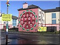
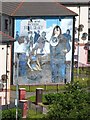
Bloody Sunday Memorial mural, Bogside
Pictured along Rossville Street
Image: © Kenneth Allen
Taken: 11 Feb 2009
0.01 miles
2
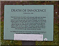
Death of Innocence
Mural to Annette McGavigan on Lecky Street, Londonderry / Derry. http://www.geograph.org.uk/photo/4775349
Image: © Ian S
Taken: 26 Dec 2015
0.02 miles

4
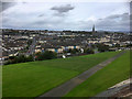
Derry, The Bogside
A view from the city walls, towards the Bogside neighborhood.
The area now known as the Bogside was originally underwater. The Foyle flowed round the island of Derry, and was first settled as the river diverted. It dried out into marshland: hence the name Bogside.
The first recorded settlers in the Bogside were listed in a 1622 survey. The influx of migrants throughout the 18th century created a significant Catholic population in Derry. Because Catholics were forbidden from living within the walls most settled in the Bogside. The steady growth of the Catholic population was reflected in the construction of the city’s first Catholic church, Long Tower (1784), and St Eugene’s Cathedral (1851).
More information: http://www.museumoffreederry.org/content/bogside (The Museum of Free Derry).
Image: © David Dixon
Taken: 26 Sep 2017
0.02 miles
5
Death of Innocence
Mural to Annette McGavigan on Lecky Street, Londonderry / Derry. http://www.geograph.org.uk/photo/4775351
Image: © Ian S
Taken: 26 Dec 2015
0.03 miles
6
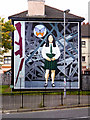
Death Of Innocence - The Annette McGavigan Mural
The large gable-wall murals by the Bogside Artists https://en.wikipedia.org/wiki/Bogside_Artists are popular tourist attractions for visitors to Derry.
This mural on the gable wall of maisonnette on the junction of Lecky Road and Westland Street close to Free Derry Corner is entitled "The Death of Innocence”. The young girl in the mural is Annette McGavigan who was 14 years when she was killed by a gunshot in crossfire between British soldiers and the IRA on 6 September 1971. After three years of The Troubles in Northern Ireland https://en.wikipedia.org/wiki/The_Troubles , Annette was the 100th civilian and the first child to be killed.
The mural was unveiled on 1 September 1999. An unfinished butterfly was placed above and to the left of her head is and a rifle was drawn along the left hand edge of the mural. In June 2006 the mural was repainted with the butterfly coloured in and the rifle was redrawn broken.
Image: © David Dixon
Taken: 26 Sep 2017
0.03 miles
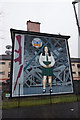
7
"You are now entering free Derry"
One of the famous Bogside murals.
Image: © Oliver Dixon
Taken: 8 Jul 2013
0.03 miles
8
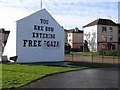
You are now entering Free Gaza
It is actually the Free Derry mural - see Image]
Image: © Kenneth Allen
Taken: 11 Feb 2009
0.03 miles
9
City walls, Derry / Londonderry
They overlook the Bogside
Image: © Kenneth Allen
Taken: 11 Feb 2009
0.03 miles
10
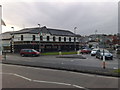
Bogside Inn, Westland St
The Bogside Inn on Westland Street in Derry's Bogside. It has since closed.
Image: © Dean Molyneaux
Taken: 18 Oct 2008
0.03 miles