IMAGES TAKEN NEAR TO
Carlisle Road, LONDONDERRY, BT48 6JL
Introduction
This page details the photographs taken nearby to Carlisle Road, BT48 6JL by members of the Geograph project.
The Geograph project started in 2005 with the aim of publishing, organising and preserving representative images for every square kilometre of Great Britain, Ireland and the Isle of Man.

There are currently over 7.5m images from over14,400 individuals and you can help contribute to the project by visiting https://www.geograph.org.uk
Image Map
Images are licensed for reuse under creativecommons.org/licenses/by-sa/2.0
Notes
- Clicking on the map will re-center to the selected point.
- The higher the marker number, the further away the image location is from the centre of the postcode.
Image Listing (585 Images Found)
Images are licensed for reuse under creativecommons.org/licenses/by-sa/2.0
Image
Details
Distance
1
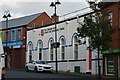
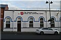
Salvation Army Church and Community Centre
Image: © N Chadwick
Taken: 21 Oct 2021
0.00 miles
2
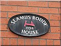
Plaque, S?amus Roddy House
It is located here Image]
Image: © Kenneth Allen
Taken: 6 Aug 2010
0.01 miles
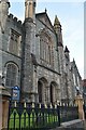
4
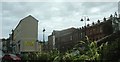
Carlisle Road and John Street from the Carlisle Circus
Image: © Eric Jones
Taken: 19 Aug 2009
0.02 miles
5
Salvation Army Church and Community Centre
Image: © N Chadwick
Taken: 21 Oct 2021
0.02 miles
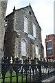
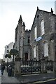
8
The Carlisle Street Presbyterian Church viewed across the roundabout at the end of Craigavon Bridge
The two figures on the roundabout represent the two communities, Loyalist and Nationalist. arms outstretched in a gesture of reconciliation.
Image: © Eric Jones
Taken: 19 Aug 2009
0.02 miles
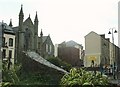
9
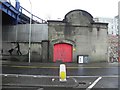
Londonderry 1920 Corporation Electric Supply
It is located at Foyle Road and adjacent to Craigavon Bridge and is an empty shell now.
There is a similar structure near Bonds Hill on the Waterside Image]
Image: © Kenneth Allen
Taken: 6 Feb 2012
0.02 miles
10
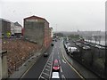
Foyle Road, Derry / Londonderry
Looking north-east from the upper deck of Craigavon Bridge.
Image: © Kenneth Allen
Taken: 6 Feb 2012
0.03 miles