IMAGES TAKEN NEAR TO
Ebrington Terrace, LONDONDERRY, BT47 6JS
Introduction
This page details the photographs taken nearby to Ebrington Terrace, BT47 6JS by members of the Geograph project.
The Geograph project started in 2005 with the aim of publishing, organising and preserving representative images for every square kilometre of Great Britain, Ireland and the Isle of Man.

There are currently over 7.5m images from over14,400 individuals and you can help contribute to the project by visiting https://www.geograph.org.uk
Image Map
Images are licensed for reuse under creativecommons.org/licenses/by-sa/2.0
Notes
- Clicking on the map will re-center to the selected point.
- The higher the marker number, the further away the image location is from the centre of the postcode.
Image Listing (187 Images Found)
Images are licensed for reuse under creativecommons.org/licenses/by-sa/2.0
Image
Details
Distance
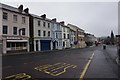
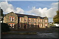
5
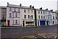
Buildings on Limavady Road
Londonderry / Derry.
Image: © Ian S
Taken: 26 Dec 2015
0.02 miles
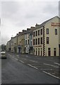
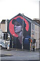
6
Cunningham Factory, Derry / Londonderry
It looks like it is closed, there was a tradition of shirt making in the city
Image: © Kenneth Allen
Taken: 23 Mar 2006
0.03 miles
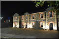
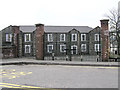
8
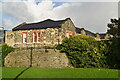
Cunningham Block, Ebrington Barracks
Grade B listed.
Image: © N Chadwick
Taken: 21 Oct 2021
0.04 miles