IMAGES TAKEN NEAR TO
Ebrington Park, LONDONDERRY, BT47 6EH
Introduction
This page details the photographs taken nearby to Ebrington Park, BT47 6EH by members of the Geograph project.
The Geograph project started in 2005 with the aim of publishing, organising and preserving representative images for every square kilometre of Great Britain, Ireland and the Isle of Man.

There are currently over 7.5m images from over14,400 individuals and you can help contribute to the project by visiting https://www.geograph.org.uk
Image Map
Images are licensed for reuse under creativecommons.org/licenses/by-sa/2.0
Notes
- Clicking on the map will re-center to the selected point.
- The higher the marker number, the further away the image location is from the centre of the postcode.
Image Listing (13 Images Found)
Images are licensed for reuse under creativecommons.org/licenses/by-sa/2.0
Image
Details
Distance
1
St Columb's Park Leisure Centre
Located in St Columb's Park near the Waterside in Derry / Londonderry
See close-up of notice here Image]
Image: © Kenneth Allen
Taken: 1 Jul 2011
0.19 miles
2
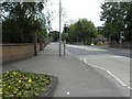
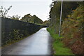
A2, Limavady Road, Derry / Londonderry
Heading north-east
Image: © Kenneth Allen
Taken: 1 Jul 2011
0.19 miles
3
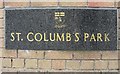
Plaque, St Columb's Park
It includes the crest of Derry City Council
Located here Image]
Image: © Kenneth Allen
Taken: 1 Jul 2011
0.20 miles

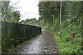
5
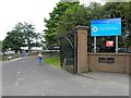
Entrance, St Columb's Park, Derry / Londonderry
It is located along Limavady Road
See close-up of plaque here Image]
Image: © Kenneth Allen
Taken: 1 Jul 2011
0.22 miles
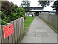
8

Council notice, St Columb's Park
It is located here Image]
Image: © Kenneth Allen
Taken: 1 Jul 2011
0.23 miles
9
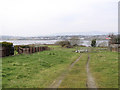
Rossbay, Derry / Londonderry
The view is looking across the river Foyle towards the City side
Image: © Kenneth Allen
Taken: 23 Mar 2006
0.23 miles