IMAGES TAKEN NEAR TO
York Street, LONDONDERRY, BT47 6DX
Introduction
This page details the photographs taken nearby to York Street, BT47 6DX by members of the Geograph project.
The Geograph project started in 2005 with the aim of publishing, organising and preserving representative images for every square kilometre of Great Britain, Ireland and the Isle of Man.

There are currently over 7.5m images from over14,400 individuals and you can help contribute to the project by visiting https://www.geograph.org.uk
Image Map
Images are licensed for reuse under creativecommons.org/licenses/by-sa/2.0
Notes
- Clicking on the map will re-center to the selected point.
- The higher the marker number, the further away the image location is from the centre of the postcode.
Image Listing (259 Images Found)
Images are licensed for reuse under creativecommons.org/licenses/by-sa/2.0
Image
Details
Distance
6
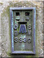
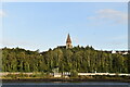
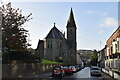
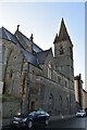
Bench Mark 3339, Derry / Londonderry
Flush bracket bench mark ,it is located at the rear of All Saints Church of Ireland; it is located here Image The number on the mark is OSBM 3339 and the mark is 17.77 metres above MSL.
Not one of my best images, but it is just a record
Image: © Kenneth Allen
Taken: 9 Apr 2010
0.04 miles
7
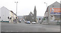
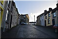
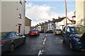
King Street and Spencer Road, Derry / Londonderry
Waiting at the traffic lights to head towards the city centre.
Image: © Kenneth Allen
Taken: 23 Mar 2006
0.05 miles