IMAGES TAKEN NEAR TO
Sheskin Park, LONDONDERRY, BT47 3DF
Introduction
This page details the photographs taken nearby to Sheskin Park, BT47 3DF by members of the Geograph project.
The Geograph project started in 2005 with the aim of publishing, organising and preserving representative images for every square kilometre of Great Britain, Ireland and the Isle of Man.

There are currently over 7.5m images from over14,400 individuals and you can help contribute to the project by visiting https://www.geograph.org.uk
Image Map
Images are licensed for reuse under creativecommons.org/licenses/by-sa/2.0
Notes
- Clicking on the map will re-center to the selected point.
- The higher the marker number, the further away the image location is from the centre of the postcode.
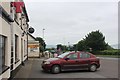
Image Listing (3 Images Found)
Images are licensed for reuse under creativecommons.org/licenses/by-sa/2.0
Image
Details
Distance
1
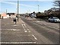
Greysteel village
The A2 from Derry to Coleraine passes through Greysteel village.
Image: © Kay Atherton
Taken: 4 Apr 2007
0.14 miles
3
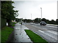
Clooney Road, Greysteel (2)
The A2 looking west towards Eglinton and Derry.
Image: © Dean Molyneaux
Taken: 23 Aug 2009
0.24 miles