IMAGES TAKEN NEAR TO
Sunningdale Drive, LONDONDERRY, BT47 2PE
Introduction
This page details the photographs taken nearby to Sunningdale Drive, BT47 2PE by members of the Geograph project.
The Geograph project started in 2005 with the aim of publishing, organising and preserving representative images for every square kilometre of Great Britain, Ireland and the Isle of Man.

There are currently over 7.5m images from over14,400 individuals and you can help contribute to the project by visiting https://www.geograph.org.uk
Image Map
Images are licensed for reuse under creativecommons.org/licenses/by-sa/2.0
Notes
- Clicking on the map will re-center to the selected point.
- The higher the marker number, the further away the image location is from the centre of the postcode.
Image Listing (4 Images Found)
Images are licensed for reuse under creativecommons.org/licenses/by-sa/2.0
Image
Details
Distance
1
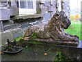
Foot scraper and Lions, Prehen House
I wonder if McNaughton Image] ever used the former?
Image: © Kenneth Allen
Taken: 7 Nov 2008
0.10 miles
2
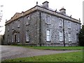
Prehen House, Derry / Londonderry
An historic house, built in 1740 for Andrew Knox, MP for Donegal, after he married Prehen heiress Honoria Tomkins two years earlier. The architect was almost certainly Michael Priestley who did a lot of work in Derry and Donegal counties around that time; his initials MP were found on a rafter in the attic.
It holds a tragic tale - see http://www.londonderrysentinel.co.uk/halloweens-haunting-tales/Prehen-House-and-its-.4636578.jp
This is where "Half-hung McNaughton" hid near Donaghahedy - Image]
Image: © Kenneth Allen
Taken: 7 Nov 2008
0.11 miles
3
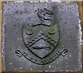
Crest of arms, Prehen House
The inscription is "Vi et Virtute" (By strength and valour)
It is located here Image]
Image: © Kenneth Allen
Taken: 7 Nov 2008
0.12 miles
4
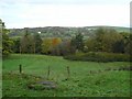
View from Prehen House
Looking north-west towards the Foyle, which is hidden from view
Image: © Kenneth Allen
Taken: 7 Nov 2008
0.14 miles