
IMAGES TAKEN NEAR TO
Tirkane Road, MAGHERA, BT46 5NE
Introduction
This page details the photographs taken nearby to Tirkane Road, BT46 5NE by members of the Geograph project.
The Geograph project started in 2005 with the aim of publishing, organising and preserving representative images for every square kilometre of Great Britain, Ireland and the Isle of Man.

There are currently over 7.5m images from over14,400 individuals and you can help contribute to the project by visiting https://www.geograph.org.uk
Image Map
Images are licensed for reuse under creativecommons.org/licenses/by-sa/2.0
Notes
- Clicking on the map will re-center to the selected point.
- The higher the marker number, the further away the image location is from the centre of the postcode.
Image Listing (3 Images Found)
Images are licensed for reuse under creativecommons.org/licenses/by-sa/2.0
Image
Details
Distance
1
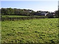
Farm buildings at Tullyheran
They blend in well amongst the trees
Image: © Kenneth Allen
Taken: 17 Oct 2007
0.15 miles
2
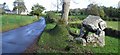
Tirnony Road, Tirnony
To the right is the Tirnony Dolmen. In 2009 the ash tree beside it was cut down for safety reasons (Health and Safety gone mad)
Image: © Kenneth Allen
Taken: 17 Oct 2007
0.25 miles
3
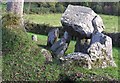
Tirnony Dolmen
It used to be in the field behind the hedge, but the latter was diverted to show it off more clearly from the roadside.
The capstone is supported by three of six upright stones, two of which form the portal. It is believed to be 4000-6000 year old megalithic burial tomb. One of the small non supporting stone was badly damaged when the capstone on the dolmen has fell off at the end of April in 2010
Image: © Kenneth Allen
Taken: 17 Oct 2007
0.25 miles