IMAGES TAKEN NEAR TO
Tobermore Road, MAGHERA, BT46 5DR
Introduction
This page details the photographs taken nearby to Tobermore Road, BT46 5DR by members of the Geograph project.
The Geograph project started in 2005 with the aim of publishing, organising and preserving representative images for every square kilometre of Great Britain, Ireland and the Isle of Man.

There are currently over 7.5m images from over14,400 individuals and you can help contribute to the project by visiting https://www.geograph.org.uk
Image Map
Images are licensed for reuse under creativecommons.org/licenses/by-sa/2.0
Notes
- Clicking on the map will re-center to the selected point.
- The higher the marker number, the further away the image location is from the centre of the postcode.
Image Listing (3 Images Found)
Images are licensed for reuse under creativecommons.org/licenses/by-sa/2.0
Image
Details
Distance
1
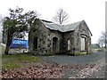
Gatehouse, Craigadick
It is located along Tobermoe Road; some building work has been started beside it and it may be part of a house extension.
Image: © Kenneth Allen
Taken: 7 Mar 2011
0.13 miles
2
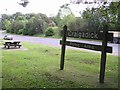
Craigadick Picnic Area
It is located to the south of Maghera
Image: © Kenneth Allen
Taken: 19 Sep 2007
0.21 miles
3
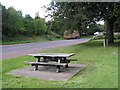
Craigadick Picnic Area
The road running past is heading for the Glenshane Road which is on the main route from Belfast to Derry / Londonderry.
Image: © Kenneth Allen
Taken: 19 Sep 2007
0.21 miles