IMAGES TAKEN NEAR TO
Castle Lane, MAGHERAFELT, BT45 8RT
Introduction
This page details the photographs taken nearby to Castle Lane, BT45 8RT by members of the Geograph project.
The Geograph project started in 2005 with the aim of publishing, organising and preserving representative images for every square kilometre of Great Britain, Ireland and the Isle of Man.

There are currently over 7.5m images from over14,400 individuals and you can help contribute to the project by visiting https://www.geograph.org.uk
Image Map
Images are licensed for reuse under creativecommons.org/licenses/by-sa/2.0
Notes
- Clicking on the map will re-center to the selected point.
- The higher the marker number, the further away the image location is from the centre of the postcode.
Image Listing (2 Images Found)
Images are licensed for reuse under creativecommons.org/licenses/by-sa/2.0
Image
Details
Distance
1
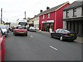
Castledawson, Derry / Londonderry
A view of the main street
Image: © Kenneth Allen
Taken: 28 Sep 2007
0.20 miles
2
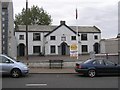
Castledawson Protestant War Memorial Hall
The plaque adds that the stone was laid by Mr Chichester Clarke on 1st April, 1929
Image: © Kenneth Allen
Taken: 28 Sep 2007
0.20 miles