IMAGES TAKEN NEAR TO
Hall Lane, MAGHERAFELT, BT45 8PF
Introduction
This page details the photographs taken nearby to Hall Lane, BT45 8PF by members of the Geograph project.
The Geograph project started in 2005 with the aim of publishing, organising and preserving representative images for every square kilometre of Great Britain, Ireland and the Isle of Man.

There are currently over 7.5m images from over14,400 individuals and you can help contribute to the project by visiting https://www.geograph.org.uk
Image Map
Images are licensed for reuse under creativecommons.org/licenses/by-sa/2.0
Notes
- Clicking on the map will re-center to the selected point.
- The higher the marker number, the further away the image location is from the centre of the postcode.
Image Listing (3 Images Found)
Images are licensed for reuse under creativecommons.org/licenses/by-sa/2.0
Image
Details
Distance
1
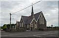
St. Mary's Church, Moyagall, Gulladuff
St. Mary's RC Church, Moyagall, Gulladuff.
Image: © Rossographer
Taken: 11 Jul 2022
0.14 miles
2
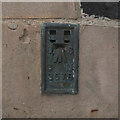
Flush Bracket, Gulladuff
Flush bracket bench mark on the north-eastern tip of St. Mary's, Gulladuff Image
The number on the bracket is OSBM 3578 and it has been levelled to 57.78m above MSL.
Image: © Rossographer
Taken: 11 Jul 2022
0.14 miles
3
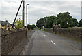
The Mayogall Road, Gulladuff
Road leading from Gulladuff/Maghera to Portglenone.
Image: © Rossographer
Taken: 11 Jul 2022
0.16 miles