IMAGES TAKEN NEAR TO
Ashbourne Dell, MAGHERAFELT, BT45 8HH
Introduction
This page details the photographs taken nearby to Ashbourne Dell, BT45 8HH by members of the Geograph project.
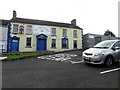
The Geograph project started in 2005 with the aim of publishing, organising and preserving representative images for every square kilometre of Great Britain, Ireland and the Isle of Man.

There are currently over 7.5m images from over14,400 individuals and you can help contribute to the project by visiting https://www.geograph.org.uk
Image Map
Images are licensed for reuse under creativecommons.org/licenses/by-sa/2.0
Notes
- Clicking on the map will re-center to the selected point.
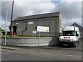
- The higher the marker number, the further away the image location is from the centre of the postcode.
Image Listing (19 Images Found)
Images are licensed for reuse under creativecommons.org/licenses/by-sa/2.0
Image
Details
Distance
1
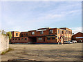
Nestle Factory, Castledawson
Built and opened by The Nestle Company in 1943 to provide an outlet for farm milk supplies in Londonderry and Tyrone replacing a number of small local creameries. The milk was manufactured into sweetened condensed milk, which was much in demand during WW2. The plant had a capacity of 10 million gallons per annum, and employed 200 persons. Post war, much of the production was exported to Africa, India, and the West Indies. Due to changed economic conditions in those countries, and in Europe, production had ceased by 1980. The building is now used for furniture manufacture.
Image: © Linda Bailey
Taken: 3 Mar 2005
0.08 miles
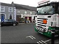
2
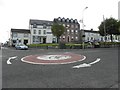
Mini roundabout, Castledawson
The junction of Moyola Road to the left, Main Street on the right and New Row ahead
Image: © Kenneth Allen
Taken: 22 Sep 2011
0.21 miles
3
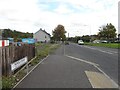
Moyola Road, Castledawson
Heading ENE; the road sign indicates that we ware in the townland of Shanemullagh
Image: © Kenneth Allen
Taken: 22 Sep 2011
0.21 miles
4
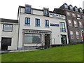
J Rainey Bookmaker / Mullan & Co / Beauty Spot
They are located at The Gravel, Main Street, Castledawson
Image: © Kenneth Allen
Taken: 22 Sep 2011
0.21 miles
5
Family Butcher, Castledawson
It is located at the corner of New Row and Main Street
Image: © Kenneth Allen
Taken: 22 Sep 2011
0.21 miles
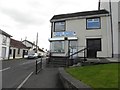
6
Health Farm Fruit Shop, Castledawson
See pavement view here Image]
Image: © Kenneth Allen
Taken: 22 Sep 2011
0.22 miles
7
Ward Design, Castledawson
They are located at The Gravel, Main Street.
Image: © Kenneth Allen
Taken: 22 Sep 2011
0.22 miles
8
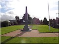
War memorial, Castledawson
It is located along Main Street
Image: © Kenneth Allen
Taken: 22 Sep 2011
0.22 miles
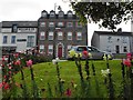
9
Moyola Park Football & Social Club, Castledawson
They are located at Chichester Club 1912 overlooking The Gravel.
Image: © Kenneth Allen
Taken: 22 Sep 2011
0.23 miles
10
1st Mayola Scout Group Hall, Castledawson
The building is the former Methodist Church
See close-up of plaque here Image]
Image: © Kenneth Allen
Taken: 22 Sep 2011
0.23 miles