IMAGES TAKEN NEAR TO
Aughrim Road, MAGHERAFELT, BT45 8HF
Introduction
This page details the photographs taken nearby to Aughrim Road, BT45 8HF by members of the Geograph project.
The Geograph project started in 2005 with the aim of publishing, organising and preserving representative images for every square kilometre of Great Britain, Ireland and the Isle of Man.

There are currently over 7.5m images from over14,400 individuals and you can help contribute to the project by visiting https://www.geograph.org.uk
Image Map
Images are licensed for reuse under creativecommons.org/licenses/by-sa/2.0
Notes
- Clicking on the map will re-center to the selected point.
- The higher the marker number, the further away the image location is from the centre of the postcode.
Image Listing (3 Images Found)
Images are licensed for reuse under creativecommons.org/licenses/by-sa/2.0
Image
Details
Distance
1
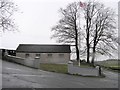
Aughrim Protestant Hall
The Union flag is kept permanently flying as some are in various parts of the province. They can be from either side of the community. The plaque states that the hall was built in 1881 and re-built in 1985.
Image: © Kenneth Allen
Taken: 13 Feb 2007
0.02 miles
2
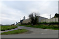
Road junction
Farm buildings at the junction of Gracefield Road and Aughrim Road.
Image: © Robert Ashby
Taken: 16 Mar 2016
0.06 miles
3
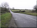
Road at Aughrim
Aughrim Protestant Hall is in the distance
Image: © Kenneth Allen
Taken: 13 Feb 2007
0.23 miles