IMAGES TAKEN NEAR TO
Killyboggin Road, MAGHERAFELT, BT45 7RN
Introduction
This page details the photographs taken nearby to Killyboggin Road, BT45 7RN by members of the Geograph project.
The Geograph project started in 2005 with the aim of publishing, organising and preserving representative images for every square kilometre of Great Britain, Ireland and the Isle of Man.

There are currently over 7.5m images from over14,400 individuals and you can help contribute to the project by visiting https://www.geograph.org.uk
Image Map
Images are licensed for reuse under creativecommons.org/licenses/by-sa/2.0
Notes
- Clicking on the map will re-center to the selected point.
- The higher the marker number, the further away the image location is from the centre of the postcode.
Image Listing (3 Images Found)
Images are licensed for reuse under creativecommons.org/licenses/by-sa/2.0
Image
Details
Distance
1
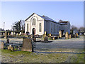
Lecumber Presbyterian Church
It is on the main road between Moneymore and Desertmartin.
Image: © Kenneth Allen
Taken: 29 Jan 2006
0.07 miles
2
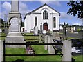
Lecumber Presbyterian Church
As seen from the main road
Image: © Kenneth Allen
Taken: 7 Aug 2007
0.07 miles
3
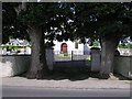
Entrance to Lecumber Church
Nice to see that the trees were retained at the gateway.
Image: © Kenneth Allen
Taken: 7 Aug 2007
0.07 miles