IMAGES TAKEN NEAR TO
Cookstown Road, MAGHERAFELT, BT45 7QF
Introduction
This page details the photographs taken nearby to Cookstown Road, BT45 7QF by members of the Geograph project.
The Geograph project started in 2005 with the aim of publishing, organising and preserving representative images for every square kilometre of Great Britain, Ireland and the Isle of Man.

There are currently over 7.5m images from over14,400 individuals and you can help contribute to the project by visiting https://www.geograph.org.uk
Image Map
Images are licensed for reuse under creativecommons.org/licenses/by-sa/2.0
Notes
- Clicking on the map will re-center to the selected point.
- The higher the marker number, the further away the image location is from the centre of the postcode.
Image Listing (4 Images Found)
Images are licensed for reuse under creativecommons.org/licenses/by-sa/2.0
Image
Details
Distance
1
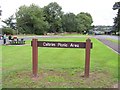
Coltrim Picnic Area
Moneymore is in the distance
Image: © Kenneth Allen
Taken: 17 Aug 2006
0.08 miles
2
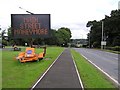
Coltrim
The sign warns of roadworks up ahead.
Image: © Kenneth Allen
Taken: 17 Aug 2006
0.08 miles
3
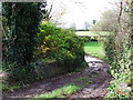
Farm lane Cookstown Road, Moneymore
Farm lane opens off the lay-by
Image: © Jude Byrne
Taken: 3 Nov 2011
0.11 miles
4
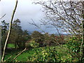
Lay-by, Cookstown Road, Moneymore
Hedgerows with the Moneymore area in the background
Image: © Jude Byrne
Taken: 3 Nov 2011
0.14 miles