IMAGES TAKEN NEAR TO
High Street, MAGHERAFELT, BT45 7PB
Introduction
This page details the photographs taken nearby to High Street, BT45 7PB by members of the Geograph project.
The Geograph project started in 2005 with the aim of publishing, organising and preserving representative images for every square kilometre of Great Britain, Ireland and the Isle of Man.

There are currently over 7.5m images from over14,400 individuals and you can help contribute to the project by visiting https://www.geograph.org.uk
Image Map
Images are licensed for reuse under creativecommons.org/licenses/by-sa/2.0
Notes
- Clicking on the map will re-center to the selected point.
- The higher the marker number, the further away the image location is from the centre of the postcode.
Image Listing (118 Images Found)
Images are licensed for reuse under creativecommons.org/licenses/by-sa/2.0
Image
Details
Distance
1
CKK's Cafe, Moneymore
Pictured along Main Street
Image: © Kenneth Allen
Taken: 6 Sep 2023
0.01 miles
2
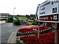
Direction sign, Moneymore
Pictured along High Street
Image: © Kenneth Allen
Taken: 20 Jul 2018
0.01 miles
3
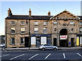
Historic buildings, High Street, Moneymore
Looking north-west from Springhill Road are the old courthouse (building on the right), now the library and the Draper's Arms Image]
One of two historically significant Market Houses in the village, the first was built c.1818 and is the centrepiece of what was originally a symmetrical range of buildings 13 bays wide. The initial design of 1818 had a cupola but was replaced by the existing turret with a clock on two faces, a 'Rundbogenstil belfry'. The late 1800s saw the first floor of the building being occupied by Moneymore Courthouse. Remarkably, the courtroom still remains intact today.
Image: © Kenneth Allen
Taken: 7 Mar 2011
0.01 miles
4
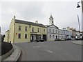
New Market House, Moneymore (rear view)
Heading WSW towards High Street
Completed in 1839 to the design of William Booth, the New Market House stands directly opposite the Old Market House. This three-storey building is 11 bays long, the central three bays break forward and are topped by a pediment. The large central archway rises through two storeys and is flanked by small rectangular doorways at the ground floor. At the first floor the archway is flanked by small circular windows and the small windows at the top storey flank a large un-inscribed panel.
Image: © Kenneth Allen
Taken: 30 Aug 2014
0.01 miles
5
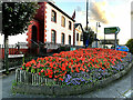
Floral display, Moneymore
Pictured along Conyngham Street
The Orange Hall is in the background
Image: © Kenneth Allen
Taken: 6 Sep 2023
0.01 miles
6
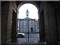
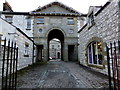
Exit, Moneymore New Market House
Looking WSW in the direction of High Street
The former courthouse can be seen through the railings
Image: © Kenneth Allen
Taken: 30 Aug 2014
0.01 miles
7
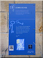
Plaque, Corn Store, Moneymore
It includes the following text:
The Corn Store was located in the yard to the rear of the New Market House.
A large building erected c.1836 and designed by William Booth provided for storage of local produce. Restoration began in 2004 to convert the buildings into luxury apartments and shops.
Pictured here Image]
Image: © Kenneth Allen
Taken: 20 Jul 2018
0.01 miles
8
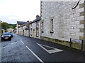
Market Street, Moneymore
Heading ENE from High Street
Image: © Kenneth Allen
Taken: 30 Aug 2014
0.02 miles
10
Market Street, Moneymore
Heading east from Main Street
Image: © Kenneth Allen
Taken: 6 Sep 2023
0.02 miles