IMAGES TAKEN NEAR TO
Tobermore Road, MAGHERAFELT, BT45 7HG
Introduction
This page details the photographs taken nearby to Tobermore Road, BT45 7HG by members of the Geograph project.
The Geograph project started in 2005 with the aim of publishing, organising and preserving representative images for every square kilometre of Great Britain, Ireland and the Isle of Man.

There are currently over 7.5m images from over14,400 individuals and you can help contribute to the project by visiting https://www.geograph.org.uk
Image Map
Images are licensed for reuse under creativecommons.org/licenses/by-sa/2.0
Notes
- Clicking on the map will re-center to the selected point.
- The higher the marker number, the further away the image location is from the centre of the postcode.
Image Listing (8 Images Found)
Images are licensed for reuse under creativecommons.org/licenses/by-sa/2.0
Image
Details
Distance
1
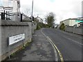
Road at Cordarragh
Looking NNW from Tobermore Road
Image: © Kenneth Allen
Taken: 14 Mar 2011
0.18 miles
2
Tobermore Road, Draperstown
Heading NNE; this section of town is in the townland of Moykeeran
Image: © Kenneth Allen
Taken: 14 Mar 2011
0.21 miles
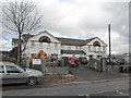
3
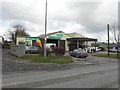
McSorley Bros, Draperstown
It is located along Tobermore Road
Image: © Kenneth Allen
Taken: 14 Mar 2011
0.22 miles
4
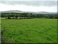
Moykeeran Townland
It is located to the east of Draperstown
Image: © Kenneth Allen
Taken: 4 Sep 2007
0.22 miles
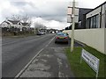
5

Workspace, Draperstown
It is located along Tobermore Road
Image: © Kenneth Allen
Taken: 14 Mar 2011
0.23 miles
6
Draperstown Surgery and Pharmacy
It is located along Tobermore Road - it replaces the old surgery here Image]
Image: © Kenneth Allen
Taken: 14 Mar 2011
0.23 miles
7
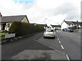
Moykeeran Crescent, Draperstown
Viewed along Tobermore Road
Image: © Kenneth Allen
Taken: 14 Mar 2011
0.24 miles
8
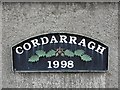
Cordarragh 1998, Draperstown
This sign is on a wall here Image]
Image: © Kenneth Allen
Taken: 14 Mar 2011
0.25 miles