IMAGES TAKEN NEAR TO
Dunlogan Road, MAGHERAFELT, BT45 7ET
Introduction
This page details the photographs taken nearby to Dunlogan Road, BT45 7ET by members of the Geograph project.
The Geograph project started in 2005 with the aim of publishing, organising and preserving representative images for every square kilometre of Great Britain, Ireland and the Isle of Man.

There are currently over 7.5m images from over14,400 individuals and you can help contribute to the project by visiting https://www.geograph.org.uk
Image Map
Images are licensed for reuse under creativecommons.org/licenses/by-sa/2.0
Notes
- Clicking on the map will re-center to the selected point.
- The higher the marker number, the further away the image location is from the centre of the postcode.
Image Listing (3 Images Found)
Images are licensed for reuse under creativecommons.org/licenses/by-sa/2.0
Image
Details
Distance
1
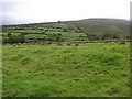
Drumderg Townland
The misty conditions dominated for most of the day.
Image: © Kenneth Allen
Taken: 4 Sep 2007
0.18 miles
2
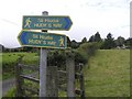
Hudy's Way / Sli Hiudai
Hudy's Way is a unique 10km (6 miles) walk encircling the village of Moneyneena near Draperstown in the heart of the Sperrin mountains. The walk begins at the impressive newly opened Community Resource Centre in Moneyneena where facilities are open and available for the weary walker. The nearby Hogan's Stand public house in the centre of the village also offers a programme of traditional music and entertainment throughout the year. This is a fully waymarked way and accompanying literature tells the storyof local man Hudy McGuigan who once famously attempted flight using home-made wings - leaping off the neighbouring Craignashoke peak and falling miserably.
Image: © Kenneth Allen
Taken: 4 Sep 2007
0.18 miles
3
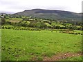
Drumderg Townland
Looking to the north. I was near Mullaghmore which is on the horizon earlier on in the day.
Image: © Kenneth Allen
Taken: 4 Sep 2007
0.20 miles