IMAGES TAKEN NEAR TO
Cavanreagh Road, MAGHERAFELT, BT45 7BX
Introduction
This page details the photographs taken nearby to Cavanreagh Road, BT45 7BX by members of the Geograph project.
The Geograph project started in 2005 with the aim of publishing, organising and preserving representative images for every square kilometre of Great Britain, Ireland and the Isle of Man.

There are currently over 7.5m images from over14,400 individuals and you can help contribute to the project by visiting https://www.geograph.org.uk
Image Map
Images are licensed for reuse under creativecommons.org/licenses/by-sa/2.0
Notes
- Clicking on the map will re-center to the selected point.
- The higher the marker number, the further away the image location is from the centre of the postcode.
Image Listing (3 Images Found)
Images are licensed for reuse under creativecommons.org/licenses/by-sa/2.0
Image
Details
Distance
1
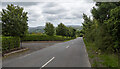
The Cavanreagh Road near Draperstown
The Cavanreagh Road (Glenelly Road on Google) a few miles south-west of Draperstown. The road rises steeply as it heads into the Sperrins.
Image: © Rossographer
Taken: 14 Aug 2021
0.18 miles
2
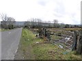
Cavanreagh Road
Heading south-east towards Draperstown / Omagh
Image: © Kenneth Allen
Taken: 14 Mar 2011
0.19 miles
3
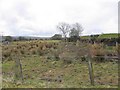
Cavanreagh Townland
Looking south-west from Cravnreagh Road
Image: © Kenneth Allen
Taken: 14 Mar 2011
0.23 miles