IMAGES TAKEN NEAR TO
Oaklea Road, MAGHERAFELT, BT45 6NH
Introduction
This page details the photographs taken nearby to Oaklea Road, BT45 6NH by members of the Geograph project.
The Geograph project started in 2005 with the aim of publishing, organising and preserving representative images for every square kilometre of Great Britain, Ireland and the Isle of Man.

There are currently over 7.5m images from over14,400 individuals and you can help contribute to the project by visiting https://www.geograph.org.uk
Image Map
Images are licensed for reuse under creativecommons.org/licenses/by-sa/2.0
Notes
- Clicking on the map will re-center to the selected point.
- The higher the marker number, the further away the image location is from the centre of the postcode.
Image Listing (1 Images Found)
Images are licensed for reuse under creativecommons.org/licenses/by-sa/2.0
Image
Details
Distance
1
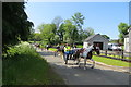
Near Ballyronan
An organised pony drive passed me unexpectedly, preceded by a marshall's car with a "Pony Drive" sign on the front, and I just managed to get this one shot. I occasionally see these pony and trap rigs on the road, usually singly, from time to time. See my photos on J1161 and J 1189.
Image: © Robert Ashby
Taken: 29 May 2016
0.09 miles