IMAGES TAKEN NEAR TO
Barrack Road, MAGHERAFELT, BT45 6LU
Introduction
This page details the photographs taken nearby to Barrack Road, BT45 6LU by members of the Geograph project.
The Geograph project started in 2005 with the aim of publishing, organising and preserving representative images for every square kilometre of Great Britain, Ireland and the Isle of Man.

There are currently over 7.5m images from over14,400 individuals and you can help contribute to the project by visiting https://www.geograph.org.uk
Image Map
Images are licensed for reuse under creativecommons.org/licenses/by-sa/2.0
Notes
- Clicking on the map will re-center to the selected point.
- The higher the marker number, the further away the image location is from the centre of the postcode.
Image Listing (3 Images Found)
Images are licensed for reuse under creativecommons.org/licenses/by-sa/2.0
Image
Details
Distance
1
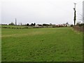
Ballymaguigan Townland
Looking north.
Image: © Kenneth Allen
Taken: 13 Feb 2007
0.15 miles
2
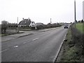
Road at Ballymaguigan
Heading towards Ballyronan.
Image: © Kenneth Allen
Taken: 13 Feb 2007
0.17 miles
3
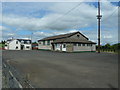
AOH hall Drumenagh
The Ancient Order Of Hibernians is an Irish-Catholic organisation founded in New York in 1836. Their regalia is quite similar to the Orange Order but differing in colour and could almost be said to be the Catholic version of the Orangemen but with very different aims. Visitors to Northern Ireland sometimes get a bit confused.
Image: © Robert Ashby
Taken: 3 Jul 2013
0.25 miles