IMAGES TAKEN NEAR TO
Shore Road, MAGHERAFELT, BT45 6LL
Introduction
This page details the photographs taken nearby to Shore Road, BT45 6LL by members of the Geograph project.
The Geograph project started in 2005 with the aim of publishing, organising and preserving representative images for every square kilometre of Great Britain, Ireland and the Isle of Man.

There are currently over 7.5m images from over14,400 individuals and you can help contribute to the project by visiting https://www.geograph.org.uk
Image Map
Images are licensed for reuse under creativecommons.org/licenses/by-sa/2.0
Notes
- Clicking on the map will re-center to the selected point.
- The higher the marker number, the further away the image location is from the centre of the postcode.
Image Listing (4 Images Found)
Images are licensed for reuse under creativecommons.org/licenses/by-sa/2.0
Image
Details
Distance
1
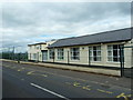
St Trea's Primary School
Situated on the Shore Road, Ballymaguigan. With all the security fencing it looks more like a prison camp.
Image: © Robert Ashby
Taken: 3 Jul 2013
0.07 miles
2
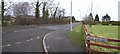
Moss Road
It is in the townland of Ballymaguigan.
Image: © Kenneth Allen
Taken: 13 Feb 2007
0.14 miles
3
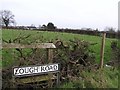
Lough Road
It is in the townland of Ballymaguigan.
Image: © Kenneth Allen
Taken: 13 Feb 2007
0.20 miles
4
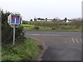
Road Ends, Lough Road
Some bright spark has reversed the road sign.
Image: © Kenneth Allen
Taken: 13 Feb 2007
0.23 miles