IMAGES TAKEN NEAR TO
Ballyneill Road, MAGHERAFELT, BT45 6JL
Introduction
This page details the photographs taken nearby to Ballyneill Road, BT45 6JL by members of the Geograph project.
The Geograph project started in 2005 with the aim of publishing, organising and preserving representative images for every square kilometre of Great Britain, Ireland and the Isle of Man.

There are currently over 7.5m images from over14,400 individuals and you can help contribute to the project by visiting https://www.geograph.org.uk
Image Map
Images are licensed for reuse under creativecommons.org/licenses/by-sa/2.0
Notes
- Clicking on the map will re-center to the selected point.
- The higher the marker number, the further away the image location is from the centre of the postcode.
Image Listing (3 Images Found)
Images are licensed for reuse under creativecommons.org/licenses/by-sa/2.0
Image
Details
Distance
1
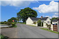
Road Junction
Approaching the junction of Belagherty Road and Ballyneil Road
Image: © Robert Ashby
Taken: 29 May 2016
0.12 miles
2
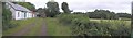
Abandoned cottage at Ballyriff
Looking west-south-west
Image: © Kenneth Allen
Taken: 26 Aug 2006
0.21 miles
3
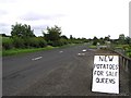
Spuds for sale at Ballyronan
In Northern Ireland, it depends what foot you dig with, the exact same spuds in other areas are known as either British Queens or Dublin Queens. There's one thing that isn't in dispute though, they are often described as "balls of flour" when boiled and are like no other when applied with a little butter and salt for excellent taste. http://www.geograph.org.uk/photo/226836
Image: © Kenneth Allen
Taken: 26 Aug 2006
0.24 miles