IMAGES TAKEN NEAR TO
Oaklea Road, MAGHERAFELT, BT45 6HX
Introduction
This page details the photographs taken nearby to Oaklea Road, BT45 6HX by members of the Geograph project.
The Geograph project started in 2005 with the aim of publishing, organising and preserving representative images for every square kilometre of Great Britain, Ireland and the Isle of Man.

There are currently over 7.5m images from over14,400 individuals and you can help contribute to the project by visiting https://www.geograph.org.uk
Image Map
Images are licensed for reuse under creativecommons.org/licenses/by-sa/2.0
Notes
- Clicking on the map will re-center to the selected point.
- The higher the marker number, the further away the image location is from the centre of the postcode.
Image Listing (4 Images Found)
Images are licensed for reuse under creativecommons.org/licenses/by-sa/2.0
Image
Details
Distance
1
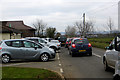
The school run
Traffic jam on Oaklea Road as parents queue to collect their children from Woods Primary School.
Image: © Robert Ashby
Taken: 16 Mar 2016
0.20 miles
2

Drumenagh Gospel Hall
A reminder over the entrance.
Image: © Kenneth Allen
Taken: 28 Dec 2006
0.20 miles
3
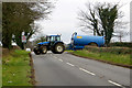
Tight turn
A large tractor on muck-spreading duties manoeuvres out of a field on to the narrow Ballyronan Road.
Image: © Robert Ashby
Taken: 16 Mar 2016
0.22 miles
4
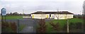
Woods Primary School
It is located to the north-west of Ballyronan.
Image: © Kenneth Allen
Taken: 28 Dec 2006
0.22 miles