IMAGES TAKEN NEAR TO
Ballyronan Road, MAGHERAFELT, BT45 6EH
Introduction
This page details the photographs taken nearby to Ballyronan Road, BT45 6EH by members of the Geograph project.
The Geograph project started in 2005 with the aim of publishing, organising and preserving representative images for every square kilometre of Great Britain, Ireland and the Isle of Man.

There are currently over 7.5m images from over14,400 individuals and you can help contribute to the project by visiting https://www.geograph.org.uk
Image Map
Images are licensed for reuse under creativecommons.org/licenses/by-sa/2.0
Notes
- Clicking on the map will re-center to the selected point.
- The higher the marker number, the further away the image location is from the centre of the postcode.
Image Listing (6 Images Found)
Images are licensed for reuse under creativecommons.org/licenses/by-sa/2.0
Image
Details
Distance


4
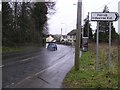
Magherafelt, County Derry / Londonderry
The car is throwing up spray from the water on the road.
Image: © Kenneth Allen
Taken: 13 Feb 2007
0.21 miles
5
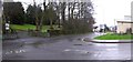
Road at Magherafelt
The turn-off to the right is for Coagh and Ballyronan. Time to pack it in for the day, the rain is getting heavier.
Image: © Kenneth Allen
Taken: 13 Feb 2007
0.21 miles
6
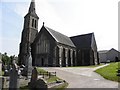
Magherafelt Presbyterian Church
It is located along Meeting Street
Image: © Kenneth Allen
Taken: 4 May 2011
0.25 miles