IMAGES TAKEN NEAR TO
Maghera Road, MAGHERAFELT, BT45 5QB
Introduction
This page details the photographs taken nearby to Maghera Road, BT45 5QB by members of the Geograph project.
The Geograph project started in 2005 with the aim of publishing, organising and preserving representative images for every square kilometre of Great Britain, Ireland and the Isle of Man.

There are currently over 7.5m images from over14,400 individuals and you can help contribute to the project by visiting https://www.geograph.org.uk
Image Map
Images are licensed for reuse under creativecommons.org/licenses/by-sa/2.0
Notes
- Clicking on the map will re-center to the selected point.
- The higher the marker number, the further away the image location is from the centre of the postcode.
Image Listing (6 Images Found)
Images are licensed for reuse under creativecommons.org/licenses/by-sa/2.0
Image
Details
Distance
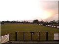
1
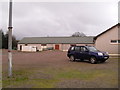
Facilities at Fortwilliam Park, Tobermore
Located on the Maghera Road.
Image: © Dean Molyneaux
Taken: 24 Jan 2010
0.13 miles
2
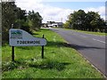
Road at Tobermore
Approaching the village from the direction of Maghera
Image: © Kenneth Allen
Taken: 19 Sep 2007
0.17 miles
3
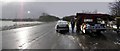
Maghera Road, Tobermore
Stopping off to purchase a few fresh vegetables. The vendor had a cold stand
Image: © Kenneth Allen
Taken: 2 Feb 2008
0.18 miles
4
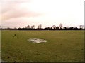
Tobermore Townland
Farmland alongside the Maghera Road - on the south bank of the Moyola River.
Image: © Dean Molyneaux
Taken: 24 Jan 2010
0.19 miles
6
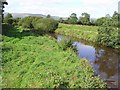
Moyola River
Looking to the north-west
Image: © Kenneth Allen
Taken: 19 Sep 2007
0.23 miles