IMAGES TAKEN NEAR TO
Motalee Road, MAGHERAFELT, BT45 5JU
Introduction
This page details the photographs taken nearby to Motalee Road, BT45 5JU by members of the Geograph project.
The Geograph project started in 2005 with the aim of publishing, organising and preserving representative images for every square kilometre of Great Britain, Ireland and the Isle of Man.

There are currently over 7.5m images from over14,400 individuals and you can help contribute to the project by visiting https://www.geograph.org.uk
Image Map
Images are licensed for reuse under creativecommons.org/licenses/by-sa/2.0
Notes
- Clicking on the map will re-center to the selected point.
- The higher the marker number, the further away the image location is from the centre of the postcode.
Image Listing (8 Images Found)
Images are licensed for reuse under creativecommons.org/licenses/by-sa/2.0
Image
Details
Distance
1
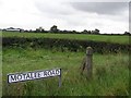
Motalee Road
It is in the townland of Luney
Image: © Kenneth Allen
Taken: 19 Sep 2007
0.15 miles
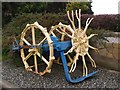
3
Roadside display at Dromore, Desertmartin
A very well maintained collection of various farm implements from a bygone age.
Image: © Kenneth Allen
Taken: 19 Sep 2007
0.19 miles
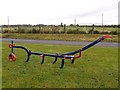
4
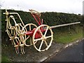
Farm Implement, Dromore
I think this was used for planting something.
Image: © Kenneth Allen
Taken: 19 Sep 2007
0.19 miles
5
Farm Implement, Dromore
Used to break open the ground, horse pulling in front and man steering behind.
Image: © Kenneth Allen
Taken: 19 Sep 2007
0.19 miles
6
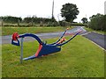
Farm Implement, Dromore
Horsepower required!
Image: © Kenneth Allen
Taken: 19 Sep 2007
0.19 miles
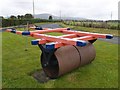
7
Farm Implement, Dromore
Used for digging out the spuds.
Image: © Kenneth Allen
Taken: 19 Sep 2007
0.19 miles
8
Farm Implement, Dromore
Where's the horse?
Image: © Kenneth Allen
Taken: 19 Sep 2007
0.19 miles