IMAGES TAKEN NEAR TO
Dunminning Road, BALLYMENA, BT44 9HQ
Introduction
This page details the photographs taken nearby to Dunminning Road, BT44 9HQ by members of the Geograph project.
The Geograph project started in 2005 with the aim of publishing, organising and preserving representative images for every square kilometre of Great Britain, Ireland and the Isle of Man.

There are currently over 7.5m images from over14,400 individuals and you can help contribute to the project by visiting https://www.geograph.org.uk
Image Map
Images are licensed for reuse under creativecommons.org/licenses/by-sa/2.0
Notes
- Clicking on the map will re-center to the selected point.
- The higher the marker number, the further away the image location is from the centre of the postcode.
Image Listing (4 Images Found)
Images are licensed for reuse under creativecommons.org/licenses/by-sa/2.0
Image
Details
Distance
1
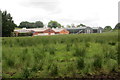
Farm buildings
Farm buildings on the Dunminning Road.
Image: © Robert Ashby
Taken: 5 Jun 2014
0.12 miles
2
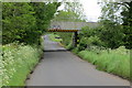
Railway bridge
Bridge carrying the railway between Ballymena and Ballymoney passes over the Ballywatermoy Road.
Image: © Robert Ashby
Taken: 5 Jun 2014
0.23 miles
3
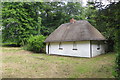
Hard times
Although not exactly derelict, Dunminning Cottage is now a sad sight with boarded-up windows though someone seems to be keeping the grass cut.
Image: © Robert Ashby
Taken: 5 Jun 2014
0.24 miles
4
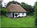
Cottage at Kildowney
Looking east. One of the nicest examples of a thatched cottage that I have seen in Northern Ireland.
Image: © Kenneth Allen
Taken: 8 Jul 2008
0.24 miles