IMAGES TAKEN NEAR TO
Tullygrawley Road, BALLYMENA, BT44 9HE
Introduction
This page details the photographs taken nearby to Tullygrawley Road, BT44 9HE by members of the Geograph project.
The Geograph project started in 2005 with the aim of publishing, organising and preserving representative images for every square kilometre of Great Britain, Ireland and the Isle of Man.

There are currently over 7.5m images from over14,400 individuals and you can help contribute to the project by visiting https://www.geograph.org.uk
Image Map
Images are licensed for reuse under creativecommons.org/licenses/by-sa/2.0
Notes
- Clicking on the map will re-center to the selected point.
- The higher the marker number, the further away the image location is from the centre of the postcode.
Image Listing (4 Images Found)
Images are licensed for reuse under creativecommons.org/licenses/by-sa/2.0
Image
Details
Distance
1
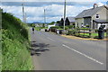
Tullygrawley Road
Farm buildings on the Tullygrawley Road near Cullybackey.
Image: © Robert Ashby
Taken: 11 Jun 2014
0.06 miles
2
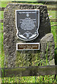
Tullygrawley Road
Tablet commemorating the Presbyterian secession from the Church Of Scotland in 1733.
Image: © Robert Ashby
Taken: 11 Jun 2014
0.06 miles
3
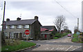
Crossroads at Moylarg
Looking to the north-east
Image: © Kenneth Allen
Taken: 25 Jan 2008
0.21 miles
4
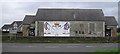
Mural near Moylarg
It is located between Dunminning and Ballymena
Image: © Kenneth Allen
Taken: 25 Jan 2008
0.24 miles