IMAGES TAKEN NEAR TO
Greenacre, BALLYMENA, BT44 9DH

Introduction

This page details the photographs taken nearby to Greenacre, BT44 9DH by members of the Geograph project.

The Geograph project started in 2005 with the aim of publishing, organising and preserving representative images for every square kilometre of Great Britain, Ireland and the Isle of Man.

There are currently over 7.5m images from over14,400 individuals and you can help contribute to the project by visiting https://www.geograph.org.uk

Image Map


Images are licensed for reuse under creativecommons.org/licenses/by-sa/2.0
Notes
  • Clicking on the map will re-center to the selected point.
  • The higher the marker number, the further away the image location is from the centre of the postcode.

Image Listing (10 Images Found)

Images are licensed for reuse under creativecommons.org/licenses/by-sa/2.0
Image
Details
Distance
1
Dunloy Orange Hall
Orange hall on Station Road, Dunloy. See also Image
Image: © Rossographer Taken: 27 Jul 2017
0.07 miles
2
Dunloy Orange Hall
Dunloy Orange Hall. The plaque reads Dunloy Orange Hall 1896.The hall has been attacked constantly over the years and is covered in paint. The window and doors have metal grills covering them.
Image: © Paul L Taken: 13 Jun 2009
0.09 miles
3
Old building, Dunloy
An old store or possibly workshop/garage on Station Road, Dunloy. At the time of writing, the building and site are advertised for sale.
Image: © Rossographer Taken: 27 Jul 2017
0.10 miles
4
Dunloy Memorial Hall
Dunloy memorial Hall. It's used by the local Presbyterian church.
Image: © Paul L Taken: 30 May 2009
0.13 miles
5
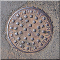
Manhole cover, Dunloy
Manhole cover on McCelland Park, Dunloy. It was cast by D.M. Moore of Coleraine - see Image Look closely - the 'R' and 'A' of Coleraine are upside down.
Image: © Rossographer Taken: 27 Jul 2017
0.15 miles
6
Level crossing, Dunloy
Automated level crossing at Station Road, Dunloy. This was previously the site of Dunloy station - Image
Image: © Rossographer Taken: 27 Jul 2017
0.22 miles
7
Test train, Dunloy
See Image The same train, hauled by 103 “Merlin”, approaching the closed station at Dunloy. See also Image
Image: © Albert Bridge Taken: 22 May 1985
0.22 miles
8
"Portrush Flyer" passing Dunloy - 1979
Preserved ex-GNR(I) 4.4.0 No. 171 "Slieve Gullion" hauls a Whitehead - Belfast - Portrush "Portrush Flyer" special excursion past Dunloy station. Although the station and signal cabin closed in 1976, the station was still staffed in 1979 to work the manual level crossing gates. The cabin, which was situated in the main building at left and is seen in Image], was the site of an unsuccessful terrorist bomb attack on 21 March 1974 - the details are recalled in this Daily Telegraph obituary: http://www.telegraph.co.uk/news/obituaries/10541586/Lieutenant-Colonel-John-Gaff-obituary.html
Image: © The Carlisle Kid Taken: 4 Aug 1979
0.22 miles
9
Main Street, Dunloy
Main Street (Garryduff Road) in the small village of Dunloy.
Image: © Rossographer Taken: 27 Jul 2017
0.23 miles
10
Dunloy station
Dunloy station opened in 1856 and closed in 1976. At the time of the photograph there was still a level crossing keeper to open the gates – now replaced by automatic barriers Image
Image: © Albert Bridge Taken: 17 Mar 1983
0.24 miles