IMAGES TAKEN NEAR TO
Doneysheil Road, BALLYMENA, BT44 8TF
Introduction
This page details the photographs taken nearby to Doneysheil Road, BT44 8TF by members of the Geograph project.
The Geograph project started in 2005 with the aim of publishing, organising and preserving representative images for every square kilometre of Great Britain, Ireland and the Isle of Man.

There are currently over 7.5m images from over14,400 individuals and you can help contribute to the project by visiting https://www.geograph.org.uk
Image Map
Images are licensed for reuse under creativecommons.org/licenses/by-sa/2.0
Notes
- Clicking on the map will re-center to the selected point.
- The higher the marker number, the further away the image location is from the centre of the postcode.
Image Listing (7 Images Found)
Images are licensed for reuse under creativecommons.org/licenses/by-sa/2.0
Image
Details
Distance
1
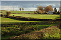
Near Rasharkin
Rich farmland looking ESE from Doneyshiel Road.
Image: © Robert Ashby
Taken: 17 Nov 2017
0.06 miles
2
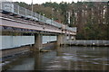
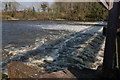
Floodgates, River Bann at Portna (1)
See Image This is a view of the floodgates (on the side facing upstream) at Portna, near Kilrea.
Image: © Albert Bridge
Taken: 2 Dec 2006
0.07 miles
3
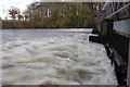
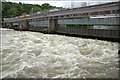
Floodgates, River Bann at Portna (2)
See Image This is a view of the floodgates (on the side facing downstream) at Portna, near Kilrea. The river is in flood after several day of heavy rain.
Image: © Albert Bridge
Taken: 2 Dec 2006
0.07 miles
4
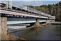
Floodgates, River Bann at Portna (3)
See Image This is a similar view but with a much-reduced flow and the gates partly open.
Image: © Albert Bridge
Taken: 25 Mar 2007
0.07 miles
5
Floodgates, River Bann at Portna (4)
See Image This is a similar view but with a much-reduced flow and the gates partly open.
Image: © Albert Bridge
Taken: 25 Mar 2007
0.07 miles
6
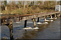
Structure, River Bann at Portna
See Image This structure is slightly downstream of the floodgates and in the same square. It is not shown on the OS map. I have no idea what it is (or was). It is well fenced, at both ends, to prevent use.
Image: © Albert Bridge
Taken: 25 Mar 2007
0.07 miles
7
Floodgates, River Bann at Portna (5)
See Image The Bann is unusually high for the time of year after an exceptionally wet June. The rain has continued into July.
Image: © Albert Bridge
Taken: 5 Jul 2007
0.07 miles