IMAGES TAKEN NEAR TO
Clady Road, BALLYMENA, BT44 8JZ
Introduction
This page details the photographs taken nearby to Clady Road, BT44 8JZ by members of the Geograph project.
The Geograph project started in 2005 with the aim of publishing, organising and preserving representative images for every square kilometre of Great Britain, Ireland and the Isle of Man.

There are currently over 7.5m images from over14,400 individuals and you can help contribute to the project by visiting https://www.geograph.org.uk
Image Map
Images are licensed for reuse under creativecommons.org/licenses/by-sa/2.0
Notes
- Clicking on the map will re-center to the selected point.
- The higher the marker number, the further away the image location is from the centre of the postcode.
Image Listing (7 Images Found)
Images are licensed for reuse under creativecommons.org/licenses/by-sa/2.0
Image
Details
Distance
1
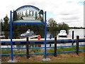
Portglenone Marina
Located along the River Bann
Image: © Kenneth Allen
Taken: 28 Apr 2012
0.17 miles
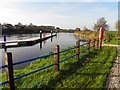
2
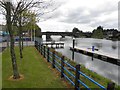
The Bann, Portglenone
Looking south from the marina
The river is flowing from Lough Neagh
Image: © Kenneth Allen
Taken: 28 Apr 2012
0.17 miles
3
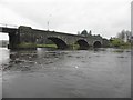
The River Bann, Portglenone
Looking south-west
Image: © Kenneth Allen
Taken: 21 Nov 2011
0.18 miles
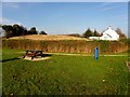
4
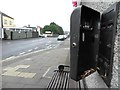
Stubbing it out, Portglenone
Pictured along Main Street
Image: © Kenneth Allen
Taken: 21 Nov 2011
0.18 miles
5
Marina, Portglenone
Pictured along the River Bann
Image: © Kenneth Allen
Taken: 14 Nov 2011
0.22 miles
6
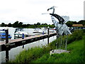
Heron sculpture, Portglenone
Pictured at the marina along the Bann River
Image: © Kenneth Allen
Taken: 15 Aug 2018
0.23 miles